IMAGES TAKEN NEAR TO
Hunters Way, MALTON, YO17 9EG
Introduction
This page details the photographs taken nearby to Hunters Way, YO17 9EG by members of the Geograph project.
The Geograph project started in 2005 with the aim of publishing, organising and preserving representative images for every square kilometre of Great Britain, Ireland and the Isle of Man.

There are currently over 7.5m images from over14,400 individuals and you can help contribute to the project by visiting https://www.geograph.org.uk
Image Map
Images are licensed for reuse under creativecommons.org/licenses/by-sa/2.0
Notes
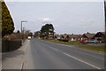
- Clicking on the map will re-center to the selected point.
- The higher the marker number, the further away the image location is from the centre of the postcode.
Image Listing (16 Images Found)
Images are licensed for reuse under creativecommons.org/licenses/by-sa/2.0
Image
Details
Distance

4

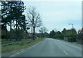
Welham Road heading south, Norton-on-Derwent
Image: © JThomas
Taken: 14 Aug 2010
0.15 miles
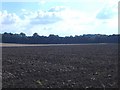
6
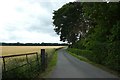
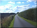
Track to the golf course
Looking along a track off Welham Road.
Image: © DS Pugh
Taken: 23 Jun 2020
0.16 miles

9
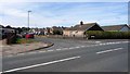
The Ridings, Norton
Suburban street of bungalows on the west side of Langton Road.
Image: © Christine Johnstone
Taken: 4 Aug 2018
0.18 miles
