IMAGES TAKEN NEAR TO
Wandales Close, MALTON, YO17 9DN
Introduction
This page details the photographs taken nearby to Wandales Close, YO17 9DN by members of the Geograph project.
The Geograph project started in 2005 with the aim of publishing, organising and preserving representative images for every square kilometre of Great Britain, Ireland and the Isle of Man.

There are currently over 7.5m images from over14,400 individuals and you can help contribute to the project by visiting https://www.geograph.org.uk
Image Map
Images are licensed for reuse under creativecommons.org/licenses/by-sa/2.0
Notes
- Clicking on the map will re-center to the selected point.
- The higher the marker number, the further away the image location is from the centre of the postcode.
Image Listing (13 Images Found)
Images are licensed for reuse under creativecommons.org/licenses/by-sa/2.0
Image
Details
Distance
2
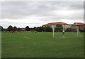
Football match at Norton Recreation Ground
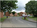
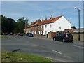
Gated entrance at the end of Dean Road
Image: © Martin Dawes
Taken: 16 Aug 2014
0.05 miles
3

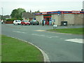
Supermarket, Hambleton Road, Norton-on-Derwent
Image: © David Smith
Taken: 17 Jun 2015
0.07 miles
6
Blocks of flats on Howe Road, Norton
Two up, two down.
Image: © Christine Johnstone
Taken: 4 Aug 2018
0.17 miles
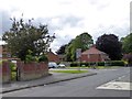
7
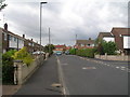
Hambleton Road, Norton on Derwent
Suburbia.
Image: © Jonathan Thacker
Taken: 22 Apr 2019
0.18 miles
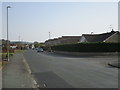
9
Bus shelter and junction with Howe Road
The B1248 (Beverley Road) passes the junction with Howe Road, which leads into a housing estate
Image: © David Smith
Taken: 17 Jun 2015
0.20 miles
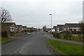
10
Houses on Beverley Road, Norton
Opposite the junction with Howe Road.
Image: © Christine Johnstone
Taken: 4 Aug 2018
0.21 miles