IMAGES TAKEN NEAR TO
Chestnut Grove, MALTON, YO17 9BZ
Introduction
This page details the photographs taken nearby to Chestnut Grove, YO17 9BZ by members of the Geograph project.
The Geograph project started in 2005 with the aim of publishing, organising and preserving representative images for every square kilometre of Great Britain, Ireland and the Isle of Man.

There are currently over 7.5m images from over14,400 individuals and you can help contribute to the project by visiting https://www.geograph.org.uk
Image Map
Images are licensed for reuse under creativecommons.org/licenses/by-sa/2.0
Notes
- Clicking on the map will re-center to the selected point.
- The higher the marker number, the further away the image location is from the centre of the postcode.
Image Listing (18 Images Found)
Images are licensed for reuse under creativecommons.org/licenses/by-sa/2.0
Image
Details
Distance
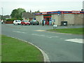
2

Supermarket, Hambleton Road, Norton-on-Derwent
Image: © David Smith
Taken: 17 Jun 2015
0.07 miles
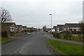
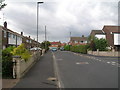
4
Hambleton Road, Norton on Derwent
Suburbia.
Image: © Jonathan Thacker
Taken: 22 Apr 2019
0.10 miles
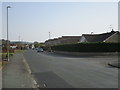
8
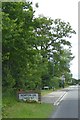
The south-eastern edge of Norton-on-Derwent
The sign omits the hyphens in the name, which appear on the OS maps; older maps simply call the place "Norton"
Image: © David Smith
Taken: 17 Jun 2015
0.14 miles
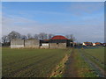
9
View to Norton Lodge Farm
From the Centenary way footpath.
Image: © Pauline E
Taken: 25 Aug 2013
0.15 miles
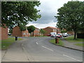
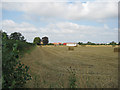
10

Welham Park taking shape
Another housing estate springing up on the edge of Norton. This was once Cheesecake Farm.
Image: © Pauline E
Taken: 25 Aug 2013
0.16 miles