IMAGES TAKEN NEAR TO
Paddock Close, MALTON, YO17 9AG
Introduction
This page details the photographs taken nearby to Paddock Close, YO17 9AG by members of the Geograph project.
The Geograph project started in 2005 with the aim of publishing, organising and preserving representative images for every square kilometre of Great Britain, Ireland and the Isle of Man.

There are currently over 7.5m images from over14,400 individuals and you can help contribute to the project by visiting https://www.geograph.org.uk
Image Map
Images are licensed for reuse under creativecommons.org/licenses/by-sa/2.0
Notes
- Clicking on the map will re-center to the selected point.
- The higher the marker number, the further away the image location is from the centre of the postcode.
Image Listing (110 Images Found)
Images are licensed for reuse under creativecommons.org/licenses/by-sa/2.0
Image
Details
Distance
1
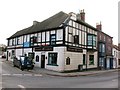
The Railway Tavern, Norton
The Railway Tavern stands on a busy junction in the centre of Norton. The pub has 18th century origins and has seen several changes of name, beginning with the Bay Horse, then Railway Inn, Railway Hotel and now Railway Tavern. The rather horrible mock Tudor half timbering of the upper floor must be relativel modern as it doesn't appear on old photographs.
Image: © Gordon Hatton
Taken: 31 Jan 2009
0.04 miles
2
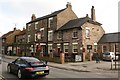
The Derwent Arms, Norton
The Derwent Arms stands on Church Street in Norton. It appears to date back to the 1830's when it was the New Inn, later becoming the Royal Oak and finally the Derwent Arms.
Image: © Gordon Hatton
Taken: 31 Jan 2009
0.05 miles
3
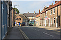
St. Nicholas Street
Looking along St. Nicholas Street next to a car park in Norton.
Image: © DS Pugh
Taken: 23 Jun 2020
0.05 miles
4
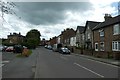
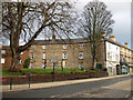
Victorian terrace, Langton Road
Nicely proportioned terrace of red brick houses dating from the 1850's on Langton Road. This part of the town has a number of large Victorian properties built originally for the middle classes of Norton and Malton.
Image: © Gordon Hatton
Taken: 31 Jan 2009
0.05 miles
5
Wold Street, Norton
Wold Street leads into the town centre past the Railway Tavern which is visible in the photograph.
Image: © Peter Church
Taken: 24 Apr 2009
0.06 miles
6
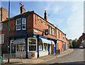
Butchers shop in Norton
This outlet stands at the junction of Wold Street and Commercial Street.
Image: © Peter Church
Taken: 24 Apr 2009
0.06 miles
7
Former Buckrose Hotel, Norton
Bears a datestone of 1899. The premises are now used by a charity. The late Mr. Henry Searle built the Buckrose Hotel. It opened as a fully licensed pub in November 1899, and closed in 1984. Landlords were: Henry Searle, Harold Searle (1913), William Searle (1921), Arthur Holmes (1925), Herbert William Stott (1937).
Image: © Pauline E
Taken: 2 Jan 2012
0.07 miles
8
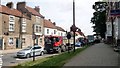
Raised pavement, Commercial Street, Norton-on-Derwent
Although the A64 by-passes Malton and Norton, traffic on Norton's main street is caught by the twin bottlenecks of a level crossing and frequent road junctions.
Image: © Christine Johnstone
Taken: 4 Aug 2018
0.07 miles
9
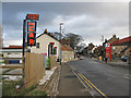
Church Street, Norton
Price per litre of unleaded fuel at the Total filling station today is 131.9p
Image: © Pauline E
Taken: 2 Jan 2012
0.07 miles
10
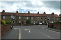
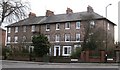
Terrace on Langton Road
Looking along St. Nicholas Street onto Langton Road in Norton.
Image: © DS Pugh
Taken: 23 Jun 2020
0.07 miles