IMAGES TAKEN NEAR TO
Langton Road, MALTON, YO17 9AD
Introduction
This page details the photographs taken nearby to Langton Road, YO17 9AD by members of the Geograph project.
The Geograph project started in 2005 with the aim of publishing, organising and preserving representative images for every square kilometre of Great Britain, Ireland and the Isle of Man.

There are currently over 7.5m images from over14,400 individuals and you can help contribute to the project by visiting https://www.geograph.org.uk
Image Map
Images are licensed for reuse under creativecommons.org/licenses/by-sa/2.0
Notes
- Clicking on the map will re-center to the selected point.
- The higher the marker number, the further away the image location is from the centre of the postcode.
Image Listing (89 Images Found)
Images are licensed for reuse under creativecommons.org/licenses/by-sa/2.0
Image
Details
Distance
1
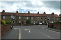
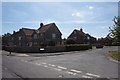
Terrace on Langton Road
Looking along St. Nicholas Street onto Langton Road in Norton.
Image: © DS Pugh
Taken: 23 Jun 2020
0.05 miles
2
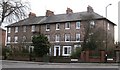
Victorian terrace, Langton Road
Nicely proportioned terrace of red brick houses dating from the 1850's on Langton Road. This part of the town has a number of large Victorian properties built originally for the middle classes of Norton and Malton.
Image: © Gordon Hatton
Taken: 31 Jan 2009
0.06 miles
3
A Terrace of houses near St Peter's Church, Norton
The street off to the left is Sutton Street, and the houses front onto Langton Road which leads south out of the town towards the villages of Langton and Birdsall.
Image: © Peter Church
Taken: 24 Apr 2009
0.07 miles
4
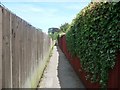
Public footpath from St Peter to St Nicholas Streets, Norton
Looking north between back garden fences.
Image: © Christine Johnstone
Taken: 4 Aug 2018
0.09 miles
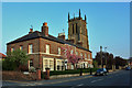
6
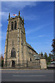
St Peter's C. of E., Norton
Taken on the day after St. George's day, and the flag is still flying.
Image: © Peter Church
Taken: 24 Apr 2009
0.09 miles
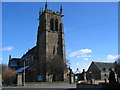
7

St Peter's Parish Church, Norton-on-Derwent
Image: © Neil Theasby
Taken: 17 Nov 2011
0.09 miles
8
St. Peters, Norton on Derwent
The church is on the south edge of the grid square. This view from St. Peters crescent looking east.
Image: © Stephen Horncastle
Taken: 4 Mar 2006
0.10 miles
9

Public footpath to Welham Road, Norton
Also to the former watermill.
Image: © Christine Johnstone
Taken: 4 Aug 2018
0.11 miles
10
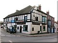
The Railway Tavern, Norton
The Railway Tavern stands on a busy junction in the centre of Norton. The pub has 18th century origins and has seen several changes of name, beginning with the Bay Horse, then Railway Inn, Railway Hotel and now Railway Tavern. The rather horrible mock Tudor half timbering of the upper floor must be relativel modern as it doesn't appear on old photographs.
Image: © Gordon Hatton
Taken: 31 Jan 2009
0.12 miles