IMAGES TAKEN NEAR TO
East Heslerton, MALTON, YO17 8RJ
Introduction
This page details the photographs taken nearby to YO17 8RJ by members of the Geograph project.
The Geograph project started in 2005 with the aim of publishing, organising and preserving representative images for every square kilometre of Great Britain, Ireland and the Isle of Man.

There are currently over 7.5m images from over14,400 individuals and you can help contribute to the project by visiting https://www.geograph.org.uk
Image Map
Images are licensed for reuse under creativecommons.org/licenses/by-sa/2.0
Notes
- Clicking on the map will re-center to the selected point.
- The higher the marker number, the further away the image location is from the centre of the postcode.
Image Listing (6 Images Found)
Images are licensed for reuse under creativecommons.org/licenses/by-sa/2.0
Image
Details
Distance
2

East Heslerton Church Room
'Church Room' is the title above the door, but I suspect this is also the village hall. The odd looking house beyond is a conversion from a Methodist chapel.
Image: © Gordon Hatton
Taken: 13 Feb 2019
0.19 miles
4

Plaque in the church porch. St Andrew's
Image: © Martin Dawes
Taken: 3 Sep 2012
0.24 miles
6
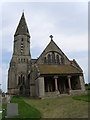
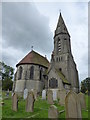
St Andrew's now in the care of The Churches Conservation Trust
Image: © Martin Dawes
Taken: 3 Sep 2012
0.25 miles