IMAGES TAKEN NEAR TO
Sherburn, MALTON, YO17 8PQ
Introduction
This page details the photographs taken nearby to YO17 8PQ by members of the Geograph project.
The Geograph project started in 2005 with the aim of publishing, organising and preserving representative images for every square kilometre of Great Britain, Ireland and the Isle of Man.

There are currently over 7.5m images from over14,400 individuals and you can help contribute to the project by visiting https://www.geograph.org.uk
Image Map
Images are licensed for reuse under creativecommons.org/licenses/by-sa/2.0
Notes
- Clicking on the map will re-center to the selected point.
- The higher the marker number, the further away the image location is from the centre of the postcode.
Image Listing (5 Images Found)
Images are licensed for reuse under creativecommons.org/licenses/by-sa/2.0
Image
Details
Distance
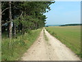
1
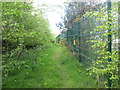
Bridleway beside the Kingspan works at Sherburn
A much better walk than along the A64, which is only a few metres away to the left
Image: © John Slater
Taken: 23 Apr 2017
0.06 miles

5
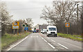
A64 entering Sherburn
A crossroads ahead is traffic light controlled.
Image: © J.Hannan-Briggs
Taken: 13 Mar 2017
0.23 miles