IMAGES TAKEN NEAR TO
Settrington, MALTON, YO17 8NU
Introduction
This page details the photographs taken nearby to YO17 8NU by members of the Geograph project.
The Geograph project started in 2005 with the aim of publishing, organising and preserving representative images for every square kilometre of Great Britain, Ireland and the Isle of Man.

There are currently over 7.5m images from over14,400 individuals and you can help contribute to the project by visiting https://www.geograph.org.uk
Image Map
Images are licensed for reuse under creativecommons.org/licenses/by-sa/2.0
Notes
- Clicking on the map will re-center to the selected point.
- The higher the marker number, the further away the image location is from the centre of the postcode.
Image Listing (13 Images Found)
Images are licensed for reuse under creativecommons.org/licenses/by-sa/2.0
Image
Details
Distance
1
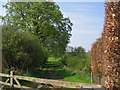
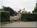
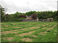
Settrington Grange - Track
The track is near the entrance to Settrington Grange and heads SW to the south edge of the grid square.
Image: © Stephen Horncastle
Taken: 8 May 2006
0.12 miles
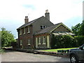
2
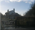
Station House, Settrington
Formerly Settrington Station
Image: © John Slater
Taken: 9 Feb 2013
0.20 miles
3
Station House from the east
From the access road to Kirk Hill
Image: © Martin Dawes
Taken: 9 Jul 2014
0.20 miles
5
Settrington Station House
Now a private house the station platform still remains a feature along the front of the house and beyond.
Image: © Martin Dawes
Taken: 25 Sep 2013
0.20 miles
6
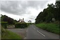
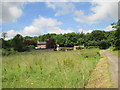
Grimston Lane at Settrington Station
The long dismantled Malton and Driffield Railway would have crossed the road here at Settrington Station. For more information on the former station see: https://en.wikipedia.org/wiki/Settrington_railway_station
Image: © DS Pugh
Taken: 23 Sep 2023
0.20 miles
7
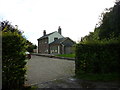
Settrington railway station (site), Yorkshire
Opened in 1853 by the Malton & Driffield Railway, this line soon became part of the North Eastern Railway empire. The station closed in 1950 to passengers, and completely in 1958.
View south from near the former level crossing towards North Grimston and Driffield. The building is now a private dwelling.
See http://www.disused-stations.org.uk/s/settrington/index.shtml for more details.
Image: © Nigel Thompson
Taken: 16 Feb 2018
0.20 miles
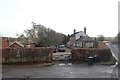
8
Settrington Station
The former station just outside Settrington. This village was once served by the Malton & Driffield Railway.
Image: © James Wells
Taken: 13 Jun 2008
0.21 miles
9
The former Settrington Station
The Station House and Weigh Office can be seen. http://www.disused-stations.org.uk/s/settrington/
Image: © Jonathan Thacker
Taken: 25 May 2015
0.22 miles
10
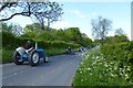
Tractor rally
Part of the Wolds Vintage Tractor Rally passing on Back Lane.
Image: © DS Pugh
Taken: 26 May 2013
0.22 miles