IMAGES TAKEN NEAR TO
Scampston, MALTON, YO17 8NH
Introduction
This page details the photographs taken nearby to YO17 8NH by members of the Geograph project.
The Geograph project started in 2005 with the aim of publishing, organising and preserving representative images for every square kilometre of Great Britain, Ireland and the Isle of Man.

There are currently over 7.5m images from over14,400 individuals and you can help contribute to the project by visiting https://www.geograph.org.uk
Image Map
Images are licensed for reuse under creativecommons.org/licenses/by-sa/2.0
Notes
- Clicking on the map will re-center to the selected point.
- The higher the marker number, the further away the image location is from the centre of the postcode.
Image Listing (5 Images Found)
Images are licensed for reuse under creativecommons.org/licenses/by-sa/2.0
Image
Details
Distance
1

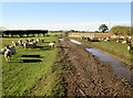
Farm pond dried up
From the bridleway at The Firs
Image: © Martin Dawes
Taken: 2 Nov 2018
0.07 miles
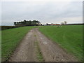
2

Field track toward The Firs
The sheep seem to think we are going to feed them
Image: © Martin Dawes
Taken: 2 Nov 2018
0.10 miles
3
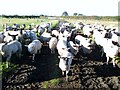
I feel like the Pied Piper
On a very sunny November day, sun low in the sky casting long shadows, I seem to be a bringer of food, they had given up before we left the field
Image: © Martin Dawes
Taken: 2 Nov 2018
0.11 miles
4
Looking towards The Firs
The Firs farm ahead.
Image: © T Eyre
Taken: 29 Mar 2017
0.17 miles