IMAGES TAKEN NEAR TO
West Knapton, MALTON, YO17 8JB
Introduction
This page details the photographs taken nearby to YO17 8JB by members of the Geograph project.
The Geograph project started in 2005 with the aim of publishing, organising and preserving representative images for every square kilometre of Great Britain, Ireland and the Isle of Man.

There are currently over 7.5m images from over14,400 individuals and you can help contribute to the project by visiting https://www.geograph.org.uk
Image Map
Images are licensed for reuse under creativecommons.org/licenses/by-sa/2.0
Notes
- Clicking on the map will re-center to the selected point.
- The higher the marker number, the further away the image location is from the centre of the postcode.
Image Listing (8 Images Found)
Images are licensed for reuse under creativecommons.org/licenses/by-sa/2.0
Image
Details
Distance
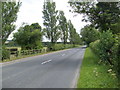
2
West Knapton village
Tiny village now bypassed by the A64 York to Scarborough road
Image: © Bill Griffiths
Taken: 21 Aug 2006
0.15 miles
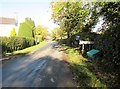
3
Pinfold
West Knap pinfold in layby off A64
Image: © Graham W Beaumont
Taken: 14 Feb 2019
0.15 miles


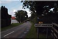
6
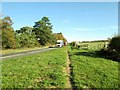
A64 and bridleway to the right
Bridleway and also the access road to Wolds Way camping and caravan park
Image: © Martin Dawes
Taken: 2 Nov 2018
0.22 miles
7
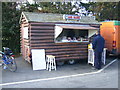
The Log Cabin Snack Bar at West Knapton
This cabin is trundled here each day and does a roaring trade serving passing motorists and commercial drivers with bacon rolls and such like.
Image: © Phil Catterall
Taken: 4 Sep 2007
0.22 miles