IMAGES TAKEN NEAR TO
Scagglethorpe, MALTON, YO17 8ED
Introduction
This page details the photographs taken nearby to YO17 8ED by members of the Geograph project.
The Geograph project started in 2005 with the aim of publishing, organising and preserving representative images for every square kilometre of Great Britain, Ireland and the Isle of Man.

There are currently over 7.5m images from over14,400 individuals and you can help contribute to the project by visiting https://www.geograph.org.uk
Image Map
Images are licensed for reuse under creativecommons.org/licenses/by-sa/2.0
Notes
- Clicking on the map will re-center to the selected point.
- The higher the marker number, the further away the image location is from the centre of the postcode.
Image Listing (10 Images Found)
Images are licensed for reuse under creativecommons.org/licenses/by-sa/2.0
Image
Details
Distance
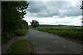
1
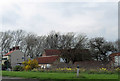
Beck House
Stands beside Settrington Beck.
Image: © Pauline E
Taken: 5 Apr 2014
0.01 miles
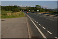
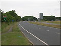
4
Old A64
Part of the old carriageway before Scagglethorpe was by-passed.
Image: © DS Pugh
Taken: 26 May 2013
0.14 miles
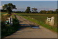
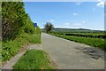
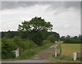
5
Lane to Scagglethorpe
Connecting to the cycle path from Malton via Brambling Fields and along the A64.
Image: © DS Pugh
Taken: 23 Jun 2020
0.14 miles
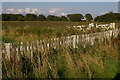
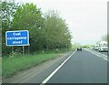
8
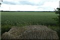
Farmland beside the A64
Looking across a wheat field from the cycle path between Brambling Fields and Scagglethorpe.
Image: © DS Pugh
Taken: 23 Jun 2020
0.21 miles