IMAGES TAKEN NEAR TO
Town Wold, MALTON, YO17 8DQ
Introduction
This page details the photographs taken nearby to Town Wold, YO17 8DQ by members of the Geograph project.
The Geograph project started in 2005 with the aim of publishing, organising and preserving representative images for every square kilometre of Great Britain, Ireland and the Isle of Man.

There are currently over 7.5m images from over14,400 individuals and you can help contribute to the project by visiting https://www.geograph.org.uk
Image Map
Images are licensed for reuse under creativecommons.org/licenses/by-sa/2.0
Notes
- Clicking on the map will re-center to the selected point.
- The higher the marker number, the further away the image location is from the centre of the postcode.
Image Listing (8 Images Found)
Images are licensed for reuse under creativecommons.org/licenses/by-sa/2.0
Image
Details
Distance
1
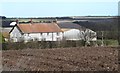
Rayslack House
Unusually for Wolds farm houses, this one is built from chalk blocks rather than brick.
Image: © Gordon Hatton
Taken: 4 Mar 2015
0.00 miles
2
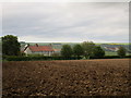
Rayslack House
Isolated Wolds farm.
Image: © Jonathan Thacker
Taken: 22 May 2015
0.01 miles
7
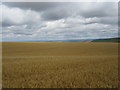
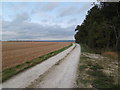
Early spring sunshine on the Wolds
Looking downhill along the bridleway to Shardale, with the field on the left ploughed ready for a spring sowing of cereals.
Image: © Gordon Hatton
Taken: 4 Mar 2015
0.23 miles
8
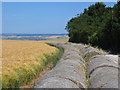
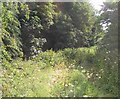
Farmland at SE895700
This grid square is all farmland with a small wood on the south edge from where this view is from.
Image: © Stephen Horncastle
Taken: 15 Jul 2006
0.23 miles