IMAGES TAKEN NEAR TO
Lascelles Lane, MALTON, YO17 7HQ
Introduction
This page details the photographs taken nearby to Lascelles Lane, YO17 7HQ by members of the Geograph project.
The Geograph project started in 2005 with the aim of publishing, organising and preserving representative images for every square kilometre of Great Britain, Ireland and the Isle of Man.

There are currently over 7.5m images from over14,400 individuals and you can help contribute to the project by visiting https://www.geograph.org.uk
Image Map
Images are licensed for reuse under creativecommons.org/licenses/by-sa/2.0
Notes
- Clicking on the map will re-center to the selected point.
- The higher the marker number, the further away the image location is from the centre of the postcode.
Image Listing (103 Images Found)
Images are licensed for reuse under creativecommons.org/licenses/by-sa/2.0
Image
Details
Distance
1
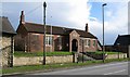
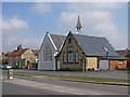
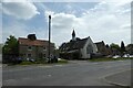
Old Malton War Memorial Hall 1914 - 1918
Located on Town Street at Old Malton.
Image: © David Rogers
Taken: 8 Mar 2009
0.04 miles
2
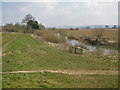
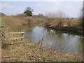
Paths by the River Derwent
View East as the river executes a right angled turn.
Image: © Pauline E
Taken: 10 Apr 2013
0.05 miles
3
Weeping birch
A lovely shape before the foliage arrives.
Image: © Pauline E
Taken: 10 Apr 2013
0.05 miles
4
Old Malton Weighbridge
Looking across Town Street towards Westgate and The Wentworth Arms. The weighbridge dates from 1887, was made by the Leeds firm of Samuel Denison & Son, and is numbered 5250.
Image: © David Rogers
Taken: 8 Mar 2009
0.05 miles
5
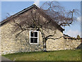
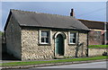
The Old Schoolhouse and Classroom Cottage
Two dwellings were developed from the former school, a Grade II listed building dating from the mid 19th century.
http://www.britishlistedbuildings.co.uk/en-389536-the-old-school-house-and-classroom-cotta
Image: © Pauline E
Taken: 10 Apr 2013
0.06 miles
6
Old Malton Town Street
Possibly the former Wesleyan Methodist Chapel at Old Malton. In the mid 1850's there was also a Primitive Methodist Chapel further up Town Street.
Image: © David Rogers
Taken: 8 Mar 2009
0.06 miles
7
River Derwent, upstream view
This is the eastern edge of the grid square. The Derwent rises on Fylingdales Moor flowing south to its confluence with the River Hertford then turning west through the Vale of Pickering, then through the steep sided valley of Kirkham Gorge. The Derwent eventually joins the Ouse at Barmby on the Marsh.
Image: © Pauline E
Taken: 10 Apr 2013
0.06 miles
8
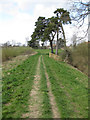
Pines by the Derwent
The River Derwent is on the left of this picture which is taken from the top of the embankment.
Image: © Pauline E
Taken: 23 Apr 2013
0.06 miles
9
The Old Chapel
Looking across Town Street in Old Malton from the junction with Westgate.
Image: © DS Pugh
Taken: 14 May 2022
0.06 miles
10
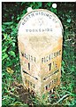
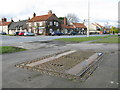
Old Milepost by the B1257, Town Street in Old Malton
Cast iron post by the B1257 (was A169), in parish of Malton (Ryedale District), Town Street, Old Malton, near Lascelles Lane, on the verge, on East side of road. Bedale rose iron casting, erected by the District Council in the 19th/20th century.
Inscription reads:-
: MALTON / 1 / {arrow->} / YORK / 19 : : NORTH RIDING OF / {rose} / YORKSHIRE / PICKERING / UDC : : PICKERING / 7½ / {<-arrow} / WHITBY / 28 :
Maker:-
: F MATTISON & Co / BEDALE. :
Grade II listed.
List Entry Number: 1220171 https://historicengland.org.uk/listing/the-list/list-entry/1220171
Milestone Society National ID: YN_MAPI01
Image: © C Minto
Taken: 19 Oct 2004
0.07 miles