IMAGES TAKEN NEAR TO
Greengate, MALTON, YO17 7EL
Introduction
This page details the photographs taken nearby to Greengate, YO17 7EL by members of the Geograph project.
The Geograph project started in 2005 with the aim of publishing, organising and preserving representative images for every square kilometre of Great Britain, Ireland and the Isle of Man.

There are currently over 7.5m images from over14,400 individuals and you can help contribute to the project by visiting https://www.geograph.org.uk
Image Map
Images are licensed for reuse under creativecommons.org/licenses/by-sa/2.0
Notes
- Clicking on the map will re-center to the selected point.
- The higher the marker number, the further away the image location is from the centre of the postcode.
Image Listing (485 Images Found)
Images are licensed for reuse under creativecommons.org/licenses/by-sa/2.0
Image
Details
Distance
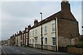
1
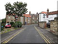
Old Maltongate, Malton
The B1257 leading north-east out of the town, seen from its junction with Church Hill
Image: © Paul Harrop
Taken: 4 May 2017
0.04 miles
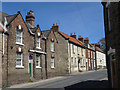
2
Period houses, Old Maltongate
The three houses nearest the camera are all grade II listed despite being constructed of different materials. Nearest the camera is Leonard House which is early 19th century and was at some point refaced with Flemish bond brickwork which in turn has been painted over. The other two houses are dates as circa 1800.
Image: © Gordon Hatton
Taken: 21 Apr 2023
0.04 miles
3
Walking the Howardian Hills and beyond #172
Walking down School Lane.
Image: © Ian S
Taken: 28 Aug 2010
0.05 miles
4
Old Maltongate Garage, Malton
At the corner of Old Maltongate and Church Hill, identified as the Old Maltongate Garage by reference to the Ordnance Survey benchmark locator; a cut mark at a height of 32.3027m can be found on the northwest face of the building.
Image: © David Rogers
Taken: 23 Feb 2011
0.05 miles
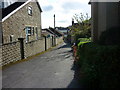
5
Junction of Old Maltongate and Church Hill
Looking back up a one way street, all vehicles to the properties on Church Hill have to come in this way and go out at the bottom into a busy road.
Image: © Martin Dawes
Taken: 25 Aug 2014
0.05 miles
6
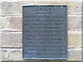
Notice on Telephone Exchange, Malton
This notice is fixed to the telephone exchange in Greengate. It says the following: "H.M. Postmaster General the owner of the land and forecourt in front of these premises has not dedicated and does not intend to dedicate as a highway the said land and forecourt or any part thereof or any way thereupon or thereover". This legal jargon would imply that the area the TE covers solely belonged to the Postmaster General and no-one else. The Postmaster General was until 1969 a Government Minister in charge of the General Post Office which provided post and telephone services. The GPO then became the Post Office Corporation, which was split up during the 1980s. Royal Mail is now responsible for the postal services whilst BT covers the telephone provision.
Image: © David Hillas
Taken: 15 Nov 2012
0.06 miles
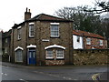
7

Malton Telephone Exchange
Situated in Greengate, this modern TE replaced the former manual TE in the mid-1960s. BT Openreach vans can be seen parked outside it. Its postcode is YO17 7EN.
Image: © David Hillas
Taken: 27 Jun 2009
0.06 miles
8
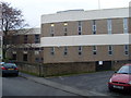
Telephone Exchange, Malton
Situated in Greengate, this modern building provides telephone and broadband services to Malton plus Amotherby, Appleton-le-Street, Broughton, Huttons Ambo, Norton, Swinton and Wykeham nearby. A BT warning notice can be seen on the dark gate to the right of the photo.
Image: © David Hillas
Taken: 15 Nov 2012
0.06 miles
9

The Old Lodge Hotel
Side elevation of this former gatehouse with a fascinating story attached. For details see Image
Image: © Pauline E
Taken: 19 Jan 2011
0.08 miles
10

Catholic Church, Malton
The church of St Leonard and St Mary is unusual in that it has medieval origins and would have been a Catholic church at that time, but following the reformation it became a Church of England, only to revert to the Catholic faith in 1971, which makes it the first church to be returned in England. The building is Grade II* listed and has a 15th century tower and 19th century spire.
Image: © Gordon Hatton
Taken: 21 Apr 2023
0.08 miles