1
Castlegate, Malton
Image: © David Brown
Taken: 16 Sep 2021
0.02 miles
2
Cottages on Castlegate
Junction of Castlegate and Sheepfoot Hill. The trees behind mark the site of the castle.
Image: © Pauline E
Taken: 2 Jan 2012
0.04 miles
3
Morrisons car park under water
To the right, over the wall, you can see the high water level of the Derwent.
Image: © Pauline E
Taken: 27 Nov 2012
0.05 miles
4
Box junction, Castlegate
Junction of Castlegate and Sheepfoot Hill.
Image: © Pauline E
Taken: 2 Jan 2012
0.05 miles
5
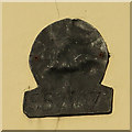
Fire plaque, Castlegate/Sheepfoot Hill
These metal plaques, or badges, erected by insurance companies, (this example was issued by the Sun Fire Office), were used to show that a property was insured. There are two types - early plaques were mostly cast in lead and displayed either a painted or engraved number which corresponded to the number of the insurance policy. The second type, known as a fire-plate was pressed from either thin copper-plate, or tinned sheet-iron.
For further information, see http://www.moleseyhistory.co.uk/books/surrey/fireplaques/index.html
Image: © Pauline E
Taken: 6 Dec 2013
0.05 miles
6
Location of old fire insurance plaque
Between the upper windows of the cream-painted building you can see a tiny black spot. This is an old fire insurance plaque and can be seen more closely at
Image
Image: © Pauline E
Taken: 6 Dec 2013
0.05 miles
7
St Leonard's with St Mary's Churchyard, Malton
Part of which has become a wildlife conservation area.
Image: © David Rogers
Taken: 23 Feb 2011
0.06 miles
8
River Derwent in flood at Malton 27th Dec 2015 (12)
From the pedestrian walkway on Castlegate bridge looking downstream with flood defence wall on the right
Image: © Martin Dawes
Taken: 27 Dec 2015
0.06 miles
9
Entrance to yard, No. 47, Sheepfoot Hill
Large double doors surrounded by an ornate stone arch, providing access to the rear of the premises.
Image: © Mike Kirby
Taken: 13 Feb 2012
0.07 miles
10
Fire Service Pre School, Sheepfoot Hill
A community run playgroup catering for children of 2 yrs upwards.
Image: © Mike Kirby
Taken: 13 Feb 2012
0.07 miles


