IMAGES TAKEN NEAR TO
Seven Street, MALTON, YO17 6YA
Introduction
This page details the photographs taken nearby to Seven Street, YO17 6YA by members of the Geograph project.
The Geograph project started in 2005 with the aim of publishing, organising and preserving representative images for every square kilometre of Great Britain, Ireland and the Isle of Man.

There are currently over 7.5m images from over14,400 individuals and you can help contribute to the project by visiting https://www.geograph.org.uk
Image Map
Images are licensed for reuse under creativecommons.org/licenses/by-sa/2.0
Notes
- Clicking on the map will re-center to the selected point.
- The higher the marker number, the further away the image location is from the centre of the postcode.
Image Listing (11 Images Found)
Images are licensed for reuse under creativecommons.org/licenses/by-sa/2.0
Image
Details
Distance

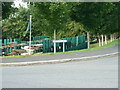
2
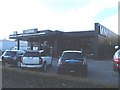
Car showroom, York Road Industrial Park, Malton
Image: © JThomas
Taken: 14 Aug 2010
0.11 miles
3
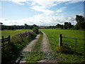
Walking the Howardian Hills and beyond #8
The track to Cherry Farm.
Image: © Ian S
Taken: 28 Aug 2010
0.12 miles

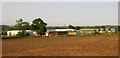
5
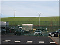
Arable hillside
Sloping land behind the car dealership in York Road. Over the brow is the A64, Malton bypass.
Image: © Pauline E
Taken: 19 Jan 2011
0.15 miles
6
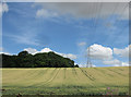
Lyons' Plantation
With lines in the sky and lines in the crop.
Image: © Pauline E
Taken: 6 Aug 2013
0.15 miles
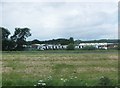
7
York Road Industrial Park, Malton
Image: © Stuart and Fiona Jackson
Taken: 7 Jun 2005
0.22 miles
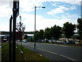
8
York Road Industrial Estate, Malton
To the southwest of Malton, on the west bank of the River Derwent.
Image: © Barbara Carr
Taken: 22 Jun 2013
0.23 miles
9
Walking the Howardian Hills and beyond #7
Hertford Way.
Image: © Ian S
Taken: 28 Aug 2010
0.23 miles
10
Walking the Howardian Hills and beyond #6
Google says Seph Way, I say it's Hertford Way
Image: © Ian S
Taken: 28 Aug 2010
0.23 miles