IMAGES TAKEN NEAR TO
Amotherby Lane, MALTON, YO17 6UP
Introduction
This page details the photographs taken nearby to Amotherby Lane, YO17 6UP by members of the Geograph project.
The Geograph project started in 2005 with the aim of publishing, organising and preserving representative images for every square kilometre of Great Britain, Ireland and the Isle of Man.

There are currently over 7.5m images from over14,400 individuals and you can help contribute to the project by visiting https://www.geograph.org.uk
Image Map
Images are licensed for reuse under creativecommons.org/licenses/by-sa/2.0
Notes
- Clicking on the map will re-center to the selected point.
- The higher the marker number, the further away the image location is from the centre of the postcode.
Image Listing (11 Images Found)
Images are licensed for reuse under creativecommons.org/licenses/by-sa/2.0
Image
Details
Distance
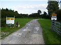
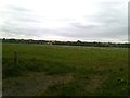
1
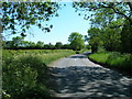
Track to Ibn Stables
Looking towards the farm from Amotherby Lane.
Image: © DS Pugh
Taken: 14 May 2022
0.04 miles
2
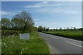
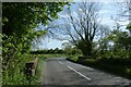
Amotherby Lane
Looking along Amotherby Lane near Ibn Stables.
Image: © DS Pugh
Taken: 14 May 2022
0.07 miles
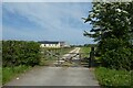
3
Rntrance to Brickyard Farm fishing lakes and camping site
Image: © Phil Catterall
Taken: 26 Sep 2006
0.07 miles
4
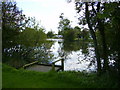
Brickyard Lakes
Camping and coarse fishing is popular on this site.
Image: © Phil Catterall
Taken: 26 Sep 2006
0.09 miles
6
Bridge over Redbridge Sewer
Looking along Amotherby Lane.
Image: © DS Pugh
Taken: 14 May 2022
0.15 miles
8
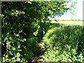
Field Opposite Brickyard Farm
Pictured from the field entrance on Amotherby Lane.
Image: © Jonathan Clitheroe
Taken: 17 Aug 2018
0.21 miles
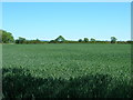
9
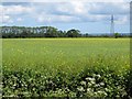
Pylon in a crop field
This is north of Amotherby near the footpath to Swinton. On the left, the trees shelter the caravan site at Brickyards Farm.
Image: © Pauline E
Taken: 31 May 2011
0.22 miles