IMAGES TAKEN NEAR TO
Marishes, MALTON, YO17 6UL
Introduction
This page details the photographs taken nearby to YO17 6UL by members of the Geograph project.
The Geograph project started in 2005 with the aim of publishing, organising and preserving representative images for every square kilometre of Great Britain, Ireland and the Isle of Man.

There are currently over 7.5m images from over14,400 individuals and you can help contribute to the project by visiting https://www.geograph.org.uk
Image Map
Images are licensed for reuse under creativecommons.org/licenses/by-sa/2.0
Notes
- Clicking on the map will re-center to the selected point.
- The higher the marker number, the further away the image location is from the centre of the postcode.
Image Listing (3 Images Found)
Images are licensed for reuse under creativecommons.org/licenses/by-sa/2.0
Image
Details
Distance
1
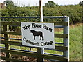
A short walk around the Vale of Pickering #132
The sign for Wray House Farm.
Image: © Ian S
Taken: 4 Sep 2010
0.11 miles
2
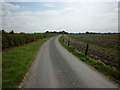
A short walk around the Vale of Pickering #131
Looking down along the way I've just walked.
Image: © Ian S
Taken: 4 Sep 2010
0.16 miles
3
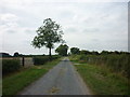
A short walk around the Vale of Pickering #133
Walking down Bean Sheaf Lane towards the Main Road.
Image: © Ian S
Taken: 4 Sep 2010
0.20 miles