IMAGES TAKEN NEAR TO
Amotherby, MALTON, YO17 6TQ
Introduction
This page details the photographs taken nearby to YO17 6TQ by members of the Geograph project.
The Geograph project started in 2005 with the aim of publishing, organising and preserving representative images for every square kilometre of Great Britain, Ireland and the Isle of Man.

There are currently over 7.5m images from over14,400 individuals and you can help contribute to the project by visiting https://www.geograph.org.uk
Image Map
Images are licensed for reuse under creativecommons.org/licenses/by-sa/2.0
Notes
- Clicking on the map will re-center to the selected point.
- The higher the marker number, the further away the image location is from the centre of the postcode.
Image Listing (16 Images Found)
Images are licensed for reuse under creativecommons.org/licenses/by-sa/2.0
Image
Details
Distance
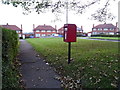
3
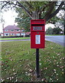
Elizabeth II postbox on the B1257, Amotherby
Postbox No. YO17 15.
See Image] for close up.
Image: © JThomas
Taken: 19 Sep 2020
0.12 miles
4
Elizabeth II postbox on the B1257, Amotherby
Postbox No. YO17 15.
See Image] for close up.
Image: © JThomas
Taken: 19 Sep 2020
0.12 miles
5
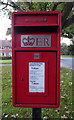
Close up, Elizabeth II postbox on the B1257, Amotherby
Image: © JThomas
Taken: 19 Sep 2020
0.12 miles
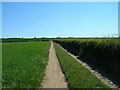
6
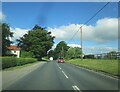
Toward Amotherby on B1257
Having just left Swinton
Image: © Martin Dawes
Taken: 29 Jun 2021
0.12 miles
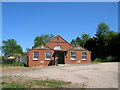
7
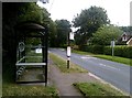
Bus Shelter and Main Road in Amotherby
Situated on the B1257 Road looking towards Swinton.
Image: © Jonathan Clitheroe
Taken: 17 Aug 2018
0.14 miles
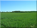
8
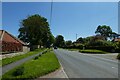
Amotherby
Looking along the B1257 leading to Malton.
Image: © DS Pugh
Taken: 30 May 2021
0.17 miles
9
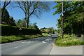
Sign for the crossroads
Looking through the village of Amotherby.
Image: © DS Pugh
Taken: 30 May 2021
0.19 miles