IMAGES TAKEN NEAR TO
Old Malton, MALTON, YO17 6RE
Introduction
This page details the photographs taken nearby to YO17 6RE by members of the Geograph project.
The Geograph project started in 2005 with the aim of publishing, organising and preserving representative images for every square kilometre of Great Britain, Ireland and the Isle of Man.

There are currently over 7.5m images from over14,400 individuals and you can help contribute to the project by visiting https://www.geograph.org.uk
Image Map
Images are licensed for reuse under creativecommons.org/licenses/by-sa/2.0
Notes
- Clicking on the map will re-center to the selected point.
- The higher the marker number, the further away the image location is from the centre of the postcode.
Image Listing (3 Images Found)
Images are licensed for reuse under creativecommons.org/licenses/by-sa/2.0
Image
Details
Distance
1
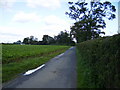
Tarmac track going all the way to Espersykes Farm
Espersykes can be seen in the trees.
Image: © Phil Catterall
Taken: 26 Sep 2006
0.05 miles
2
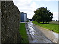
Espersykes Farm buildings and track
The track goes NNW from here to Wykeham. It is unmetalled but passable with care in a normal saloon car.
Image: © Phil Catterall
Taken: 26 Sep 2006
0.07 miles
3
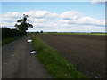
The track linking Espersykes with Wykeham
Track fairly potholed in Sept 2006 but passable with care in a normal saloon car.
Image: © Phil Catterall
Taken: 26 Sep 2006
0.14 miles