IMAGES TAKEN NEAR TO
Swinton Grange, MALTON, YO17 6QT
Introduction
This page details the photographs taken nearby to YO17 6QT by members of the Geograph project.
The Geograph project started in 2005 with the aim of publishing, organising and preserving representative images for every square kilometre of Great Britain, Ireland and the Isle of Man.

There are currently over 7.5m images from over14,400 individuals and you can help contribute to the project by visiting https://www.geograph.org.uk
Image Map
Images are licensed for reuse under creativecommons.org/licenses/by-sa/2.0
Notes
- Clicking on the map will re-center to the selected point.
- The higher the marker number, the further away the image location is from the centre of the postcode.
Image Listing (6 Images Found)
Images are licensed for reuse under creativecommons.org/licenses/by-sa/2.0
Image
Details
Distance
1
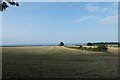
Field boundary north of Braygate Street
Looking across a field to the north of the road.
Image: © DS Pugh
Taken: 5 Sep 2021
0.18 miles
2
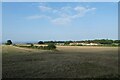
Fields near Home Farm
Looking across farmland from Braygate Street.
Image: © DS Pugh
Taken: 5 Sep 2021
0.18 miles
3
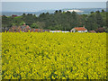
Drowning in the yellow stuff
A view over Home Farm across an oilseed rape crop field. Derived from the Latin word, 'rapum' meaning 'turnip'. Today turnip rapes, and the similar but more common swede rapes, are grown for their oil and are easily recognised by their bright yellow flowers. It is known as a 'break crop', i.e. one that improves the yield of the following cereal crop. The oil produced from the seeds is widely used by the food industry and is now being increasingly processed for use as biodiesel.
Image: © Pauline E
Taken: 13 May 2012
0.19 miles
4
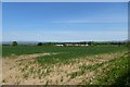
Towards Home Farm
Looking across the fields from Braygate Street.
Image: © DS Pugh
Taken: 26 May 2013
0.22 miles
5
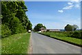
Trigger Castle
Looking along Braygate Street.
Image: © DS Pugh
Taken: 26 May 2013
0.23 miles
6
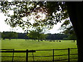
Stock grazing near Home Farm Swinton Grange
Image: © Phil Catterall
Taken: 6 Aug 2006
0.25 miles