IMAGES TAKEN NEAR TO
White Cottages, MALTON, YO17 6QN
Introduction
This page details the photographs taken nearby to White Cottages, YO17 6QN by members of the Geograph project.
The Geograph project started in 2005 with the aim of publishing, organising and preserving representative images for every square kilometre of Great Britain, Ireland and the Isle of Man.

There are currently over 7.5m images from over14,400 individuals and you can help contribute to the project by visiting https://www.geograph.org.uk
Image Map
Images are licensed for reuse under creativecommons.org/licenses/by-sa/2.0
Notes
- Clicking on the map will re-center to the selected point.
- The higher the marker number, the further away the image location is from the centre of the postcode.
Image Listing (10 Images Found)
Images are licensed for reuse under creativecommons.org/licenses/by-sa/2.0
Image
Details
Distance
1

Broughton main street
In fact, almost the only street in this little dead end village just off the B1257.
Image: © Gordon Hatton
Taken: 25 Jul 2023
0.04 miles
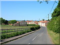
2

Broughton
The village of Broughton is on the B1257 NW of Malton. This view looking NW.
Image: © Stephen Horncastle
Taken: 8 May 2006
0.08 miles
3
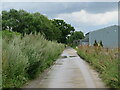
Farm access road at Broughton
The concrete surfaced road is here following the course of the old NER Thirsk and Malton Railway line.
Image: © Gordon Hatton
Taken: 25 Jul 2023
0.14 miles
4

Farm buildings, Breedycroft Lane
Viewed from Broughton Green Lane (Path).
Image: © Pauline E
Taken: 24 Oct 2011
0.16 miles
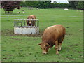
5

Farm buildings on Breedycroft Lane, Broughton
Image: © Ian S
Taken: 20 Oct 2011
0.17 miles
6
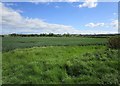
Wheat field
Looking towards Broughton from Moor Lane.
Image: © Jonathan Thacker
Taken: 26 May 2019
0.17 miles
7

Towards Broughton
Looking across farmland from the B1257.
Image: © DS Pugh
Taken: 30 May 2021
0.19 miles
10
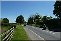
Motorcycle near Broughton
Looking along the B1257 Malton Road.
Image: © DS Pugh
Taken: 30 May 2021
0.23 miles