IMAGES TAKEN NEAR TO
Quarry Hill, MALTON, YO17 6PQ
Introduction
This page details the photographs taken nearby to Quarry Hill, YO17 6PQ by members of the Geograph project.
The Geograph project started in 2005 with the aim of publishing, organising and preserving representative images for every square kilometre of Great Britain, Ireland and the Isle of Man.

There are currently over 7.5m images from over14,400 individuals and you can help contribute to the project by visiting https://www.geograph.org.uk
Image Map
Images are licensed for reuse under creativecommons.org/licenses/by-sa/2.0
Notes
- Clicking on the map will re-center to the selected point.
- The higher the marker number, the further away the image location is from the centre of the postcode.
Image Listing (19 Images Found)
Images are licensed for reuse under creativecommons.org/licenses/by-sa/2.0
Image
Details
Distance
1

Entering Appleton-le-Street
Heading into the village on foot from Amotherby along the B1257.
Image: © Jonathan Clitheroe
Taken: 5 Aug 2022
0.11 miles
2
Agricultural building, Appleton le Street
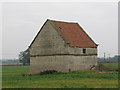
An interesting little building in a field close to the village. It is well constructed of local limestone, with a string course at mid height, pantile roof and stone kneelers, but what was its purpose? There is no door large enough for animals and no sign of a hay loft, so could it have been a dovecote? One hesitates to call it a barn.
Added information 09/17.....The building is indeed a dovecote and dates from the late 17th or early 18th century. Inside are nest boxes around all four walls. Grade two listed.
Image: © Gordon Hatton
Taken: 7 Oct 2007
0.15 miles
3

Walking the Howardian Hills and beyond #81
I had to take a photo of this notice.
Image: © Ian S
Taken: 28 Aug 2010
0.16 miles
4
Dovecote at Appleton le Street
Probably dates from the fifteenth or sixteenth centuries. https://historicengland.org.uk/listing/the-list/list-entry/1018713
Image: © Jonathan Thacker
Taken: 26 May 2019
0.16 miles
6

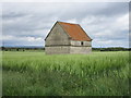
Oilseed rape crop, Appleton-le-Street
Crop field near Whitefield Farm with isolated farm building. The building seems in good repair, with a few pantiles missing from the roof.
Image: © Pauline E
Taken: 4 Jun 2013
0.16 miles
7
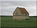
Isolated, stone farm building
A pantiled farm building sits in a crop of oilseed rape. Close to Whitefield Farm.
Image: © Pauline E
Taken: 4 Jun 2013
0.16 miles
8
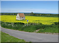
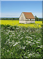
Minor road near Whitefield Farm
A view to the distant moors across an oilseed rape crop. The stone and pantiled building stands alone and appears to be doorless.
Image: © Pauline E
Taken: 4 Jun 2013
0.16 miles
9

Walking the Howardian Hills and beyond #82
That's the way I'm going.
Image: © Ian S
Taken: 28 Aug 2010
0.17 miles
10
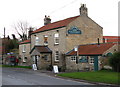
The Cresswell Arms Appleton-le-Street
A classic stone-built inn dating back to the 1800s when it was flanked by a blacksmith and a butcher.
Image: © David Rogers
Taken: 8 Mar 2009
0.20 miles