IMAGES TAKEN NEAR TO
Butterwick Road, MALTON, YO17 6PP
Introduction
This page details the photographs taken nearby to Butterwick Road, YO17 6PP by members of the Geograph project.
The Geograph project started in 2005 with the aim of publishing, organising and preserving representative images for every square kilometre of Great Britain, Ireland and the Isle of Man.

There are currently over 7.5m images from over14,400 individuals and you can help contribute to the project by visiting https://www.geograph.org.uk
Image Map
Images are licensed for reuse under creativecommons.org/licenses/by-sa/2.0
Notes
- Clicking on the map will re-center to the selected point.
- The higher the marker number, the further away the image location is from the centre of the postcode.
Image Listing (4 Images Found)
Images are licensed for reuse under creativecommons.org/licenses/by-sa/2.0
Image
Details
Distance
1
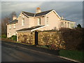
Barton-le-Street railway station (site), Yorkshire
Opened in 1853 as a branch of the York Berwick & Newcastle Railway's line from Thirsk to Malton, this station closed to passengers in 1931 and completely in 1964.
The line crossed the road left to right behind the middle part of the building - the old station house has since been extended in several different directions.
See http://www.disused-stations.org.uk/b/barton_le_street/index.shtml for more details.
Image: © Nigel Thompson
Taken: 2 Feb 2008
0.01 miles
2
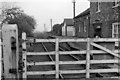
Barton-le- Street Station
View eastwards, towards Malton. The station was closed 30 years earlier on 1/1/31, and in 1961 had probably been converted to a private house, but the line was not closed until 10/8/64
Image: © Ben Brooksbank
Taken: 18 Apr 1961
0.04 miles
4
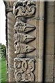
Barton-le-Street, St. Michael and All Angels Church: The north porch (detail) 6
Image: © Michael Garlick
Taken: 2 Oct 2018
0.09 miles