IMAGES TAKEN NEAR TO
Skeldergate, YORK, YO1 6WN
Introduction
This page details the photographs taken nearby to Skeldergate, YO1 6WN by members of the Geograph project.
The Geograph project started in 2005 with the aim of publishing, organising and preserving representative images for every square kilometre of Great Britain, Ireland and the Isle of Man.

There are currently over 7.5m images from over14,400 individuals and you can help contribute to the project by visiting https://www.geograph.org.uk
Image Map
Images are licensed for reuse under creativecommons.org/licenses/by-sa/2.0
Notes
- Clicking on the map will re-center to the selected point.
- The higher the marker number, the further away the image location is from the centre of the postcode.
Image Listing (2447 Images Found)
Images are licensed for reuse under creativecommons.org/licenses/by-sa/2.0
Image
Details
Distance
1
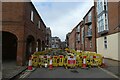
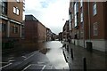
Gas works on Skeldergate
Looking along Skeldergate with gas works resulting in a temporary closure.
Image: © DS Pugh
Taken: 26 Feb 2023
0.00 miles
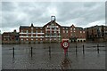
2
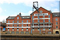
Former warehouses, Queen's Staithe, York
An excellent example of how to reuse old commercial buildings.
Image: © Michael Fox
Taken: 7 Apr 2011
0.01 miles
3
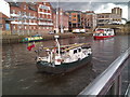
River Ouse at Queens Staith
Pleasure vessel'Rain Witch' heading upstream and River cruise boat downstream.
Image: © James Allan
Taken: 24 Aug 2017
0.01 miles
5
Closed due to flooding
Looking at the River Ouse on Skeldergate.
Image: © DS Pugh
Taken: 21 Jan 2021
0.01 miles
8
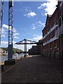
Cranes along Queens Staith, River Ouse, York
The smaller crane in the background of this photo is being considered for demolition. Over 100 years old this is a reminder of the once industrial heritage of this section of the Ouse, right in the heart of the City.
York Sea Cadets, who are based in the building nearby, have sought permission to demolish it as it requires work to make it safe. Having said that there is nothing there stopping anyone from walking around it so it's unclear just how dangerous it actually is.
Image: © hayley green
Taken: 2 Jun 2013
0.02 miles
9
Woodsmill
Looking towards Queen's Staithe across the flooded River Ouse.
Image: © DS Pugh
Taken: 23 May 2021
0.02 miles
10

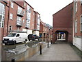
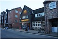
Buckingham Street, York
Early 19th century terraced housing. The decorative door cases suggest they were not intended for the lowest classes of workers.
Image: © Alan Murray-Rust
Taken: 9 Dec 2018
0.02 miles