IMAGES TAKEN NEAR TO
Dewsbury Terrace, YORK, YO1 6HA
Introduction
This page details the photographs taken nearby to Dewsbury Terrace, YO1 6HA by members of the Geograph project.
The Geograph project started in 2005 with the aim of publishing, organising and preserving representative images for every square kilometre of Great Britain, Ireland and the Isle of Man.

There are currently over 7.5m images from over14,400 individuals and you can help contribute to the project by visiting https://www.geograph.org.uk
Image Map
Images are licensed for reuse under creativecommons.org/licenses/by-sa/2.0
Notes
- Clicking on the map will re-center to the selected point.
- The higher the marker number, the further away the image location is from the centre of the postcode.
Image Listing (1545 Images Found)
Images are licensed for reuse under creativecommons.org/licenses/by-sa/2.0
Image
Details
Distance
1
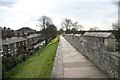
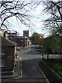
City walls
York City walls and Dewsbury Cottages near Mickelgate Bar
Image: © Richard Croft
Taken: 15 Apr 2008
0.00 miles
2
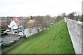
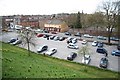
Nunnery Lane
City Walls moat and Nunnery Lane car park
Image: © Richard Croft
Taken: 15 Apr 2008
0.01 miles
3
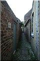
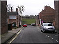
Back Dewsbury Terrace
Looking along the back alley between Dewsbury Terrace and Priory Street.
Image: © DS Pugh
Taken: 1 Oct 2021
0.01 miles
4
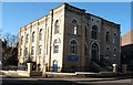
St Columba United Reformed Church, Priory Street
Maybe Priory Street should have been named 'Chapel Street' as three non conformist churches are situated in the street and each seems determined to outdo the others in size [though maybe not in good taste architecturally].
The URC building is a big cuboid of pale brick and round arched windows. Apparently there was a central pediment and corner tower, both removed in 1949.
Image: © Gordon Hatton
Taken: 30 Jan 2008
0.02 miles
5
Church near Dewsbury Terrace
Seen from York city wall near Micklegate.
Image: © Stanley Howe
Taken: 19 Apr 2007
0.02 miles
7
Nunnery Lane
Nunnery Lane car park from the City Walls
Image: © Richard Croft
Taken: 15 Apr 2008
0.02 miles
8
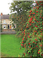
Rowan berries by York city walls
The name Rowntree is of course closely linked with York, so the tree is in a way a symbol of the city.
Image: © Stephen Craven
Taken: 31 Aug 2015
0.02 miles
9

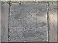
Benchmark (?) on York city wall pavement
Not shown on OS maps to which I have access.
Image: © Stanley Howe
Taken: 19 Apr 2007
0.02 miles
10
York City Walls, Walkway
York has many intact city walls and some sections of the walls date back to Roman times although the majority of the wall dates from the 12th to the 14th century, with a few small areas which were restored in the Victorian period.
This is etched into the south walkway.
Image: © Lisa Jarvis
Taken: 19 Oct 2007
0.02 miles