IMAGES TAKEN NEAR TO
Marton Road, BRIDLINGTON, YO16 7PU
Introduction
This page details the photographs taken nearby to Marton Road, YO16 7PU by members of the Geograph project.
The Geograph project started in 2005 with the aim of publishing, organising and preserving representative images for every square kilometre of Great Britain, Ireland and the Isle of Man.

There are currently over 7.5m images from over14,400 individuals and you can help contribute to the project by visiting https://www.geograph.org.uk
Image Map
Images are licensed for reuse under creativecommons.org/licenses/by-sa/2.0
Notes
- Clicking on the map will re-center to the selected point.
- The higher the marker number, the further away the image location is from the centre of the postcode.
Image Listing (190 Images Found)
Images are licensed for reuse under creativecommons.org/licenses/by-sa/2.0
Image
Details
Distance
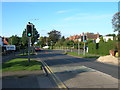
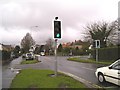
7
Traffic Lights on B1255 Marton Road
At the junction with Bempton Road, on the right
Image: © Martin Dawes
Taken: 14 Jun 2016
0.04 miles
8
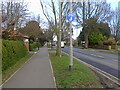
Dual use path beside Marton Road (B1255)
Taken with a vintage low resolution camera.
Image: © JThomas
Taken: 4 Mar 2023
0.04 miles
10
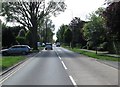
Marton Road toward the Old Town Bridlington
Image: © Martin Dawes
Taken: 14 Jun 2016
0.05 miles