IMAGES TAKEN NEAR TO
Queensgate, BRIDLINGTON, YO16 7ND
Introduction
This page details the photographs taken nearby to Queensgate, YO16 7ND by members of the Geograph project.
The Geograph project started in 2005 with the aim of publishing, organising and preserving representative images for every square kilometre of Great Britain, Ireland and the Isle of Man.

There are currently over 7.5m images from over14,400 individuals and you can help contribute to the project by visiting https://www.geograph.org.uk
Image Map
Images are licensed for reuse under creativecommons.org/licenses/by-sa/2.0
Notes
- Clicking on the map will re-center to the selected point.
- The higher the marker number, the further away the image location is from the centre of the postcode.
Image Listing (645 Images Found)
Images are licensed for reuse under creativecommons.org/licenses/by-sa/2.0
Image
Details
Distance
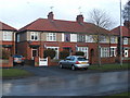
5
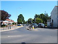
Queensgate, Bridlington
Looking east from the junction with St John's Street.
Image: © Stefan De Wit
Taken: 13 Jul 2018
0.03 miles
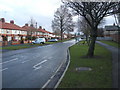
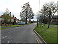
6
Tyre fitters on St John's Street, Bridlington
New signage since 2010.
See Image]
Image: © Stefan De Wit
Taken: 13 Jul 2018
0.03 miles

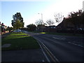
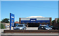
8

Kwik Fit Garage
On St John's Street, Bridlington.
Image: © Ian S
Taken: 29 Nov 2017
0.03 miles
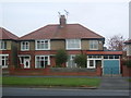
10
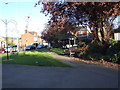
Small park beside St John's Street, Bridlington
Image: © Stefan De Wit
Taken: 30 Oct 2010
0.04 miles