IMAGES TAKEN NEAR TO
Sewerby Road, BRIDLINGTON, YO16 7DS
Introduction
This page details the photographs taken nearby to Sewerby Road, YO16 7DS by members of the Geograph project.
The Geograph project started in 2005 with the aim of publishing, organising and preserving representative images for every square kilometre of Great Britain, Ireland and the Isle of Man.

There are currently over 7.5m images from over14,400 individuals and you can help contribute to the project by visiting https://www.geograph.org.uk
Image Map
Images are licensed for reuse under creativecommons.org/licenses/by-sa/2.0
Notes
- Clicking on the map will re-center to the selected point.
- The higher the marker number, the further away the image location is from the centre of the postcode.
Image Listing (238 Images Found)
Images are licensed for reuse under creativecommons.org/licenses/by-sa/2.0
Image
Details
Distance
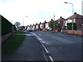
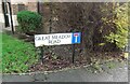
2
Sewerby Road, Bridlington
Sewerby Road is a residential road in the coastal town of Bridlington, in East Yorkshire. It is on the route of National Cycle Network route 1.
Image: © Malc McDonald
Taken: 16 Jun 2021
0.02 miles
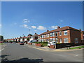
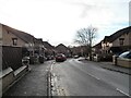
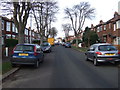
4

Sewerby Road, Bridlington
Heading towards Bridlington Old Town.
Image: © JThomas
Taken: 11 Apr 2010
0.02 miles
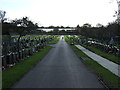
9

Cemetery Lodge
Designed by Alfred Smith and built about 1880 https://historicengland.org.uk/listing/the-list/list-entry/1281703
Image: © Jonathan Thacker
Taken: 10 Nov 2018
0.04 miles
