IMAGES TAKEN NEAR TO
Mill Close, BRIDLINGTON, YO16 7AW
Introduction
This page details the photographs taken nearby to Mill Close, YO16 7AW by members of the Geograph project.
The Geograph project started in 2005 with the aim of publishing, organising and preserving representative images for every square kilometre of Great Britain, Ireland and the Isle of Man.

There are currently over 7.5m images from over14,400 individuals and you can help contribute to the project by visiting https://www.geograph.org.uk
Image Map
Images are licensed for reuse under creativecommons.org/licenses/by-sa/2.0
Notes
- Clicking on the map will re-center to the selected point.
- The higher the marker number, the further away the image location is from the centre of the postcode.
Image Listing (435 Images Found)
Images are licensed for reuse under creativecommons.org/licenses/by-sa/2.0
Image
Details
Distance
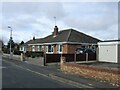
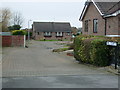
6
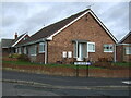
Bungalow on Mill Lane
Junction with Millbank.
Image: © JThomas
Taken: 20 Feb 2023
0.05 miles
7
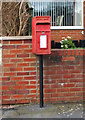
Elizabeth II postbox on Scarborough Crescent, Bridlington
Image: © JThomas
Taken: 7 Feb 2016
0.05 miles
8
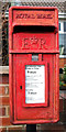
Close up, Elizabeth II postbox on Scarborough Crescent, Bridlington
Image: © JThomas
Taken: 7 Feb 2016
0.05 miles
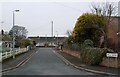
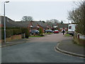
9
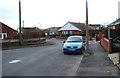
Scarborough Crescent, Bridlington
Looking west - showing position of Postbox No. YO16 77.
See Image] for postbox.
Image: © JThomas
Taken: 7 Feb 2016
0.05 miles