IMAGES TAKEN NEAR TO
Woldgate, BRIDLINGTON, YO16 4XE
Introduction
This page details the photographs taken nearby to Woldgate, YO16 4XE by members of the Geograph project.
The Geograph project started in 2005 with the aim of publishing, organising and preserving representative images for every square kilometre of Great Britain, Ireland and the Isle of Man.

There are currently over 7.5m images from over14,400 individuals and you can help contribute to the project by visiting https://www.geograph.org.uk
Image Map
Images are licensed for reuse under creativecommons.org/licenses/by-sa/2.0
Notes
- Clicking on the map will re-center to the selected point.
- The higher the marker number, the further away the image location is from the centre of the postcode.
Image Listing (72 Images Found)
Images are licensed for reuse under creativecommons.org/licenses/by-sa/2.0
Image
Details
Distance
1
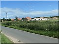
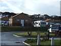
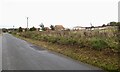
Woldgate Travellers' Site, Bridlington
Each amenity block has kitchen, shower and toilet facilities. There is an electric and water supply to each pitch. The site is run by the East Riding of Yorkshire Council.
Image: © Christine Johnstone
Taken: 6 Jul 2020
0.01 miles
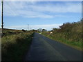
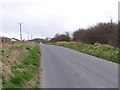
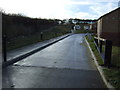
6
Woldgate
Looking along Woldgate leading west from Bridlington.
Image: © DS Pugh
Taken: 3 Jul 2021
0.04 miles