IMAGES TAKEN NEAR TO
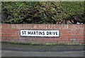
St. Martins Drive, BRIDLINGTON, YO16 4NH
Introduction
This page details the photographs taken nearby to St. Martins Drive, YO16 4NH by members of the Geograph project.
The Geograph project started in 2005 with the aim of publishing, organising and preserving representative images for every square kilometre of Great Britain, Ireland and the Isle of Man.

There are currently over 7.5m images from over14,400 individuals and you can help contribute to the project by visiting https://www.geograph.org.uk
Image Map
Images are licensed for reuse under creativecommons.org/licenses/by-sa/2.0
Notes
- Clicking on the map will re-center to the selected point.
- The higher the marker number, the further away the image location is from the centre of the postcode.
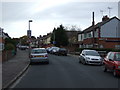
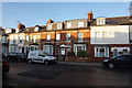
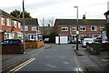
Image Listing (403 Images Found)
Images are licensed for reuse under creativecommons.org/licenses/by-sa/2.0
Image
Details
Distance
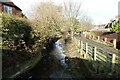
4
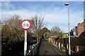
No cycling on Gypsey Bank
Path beside the Gypsey Race.
Image: © JThomas
Taken: 29 Jan 2023
0.03 miles
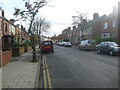
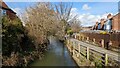
7
The Gypsey Race
Looking upstream from the bridge on Midway Avenue.
Image: © JThomas
Taken: 29 Jan 2023
0.04 miles
8
The Gypsey Race in spate #19
Looking north west from the bridge on Midway Avenue.
Image: © JThomas
Taken: 25 Feb 2024
0.04 miles