IMAGES TAKEN NEAR TO
Ashville Street, BRIDLINGTON, YO16 4EW
Introduction
This page details the photographs taken nearby to Ashville Street, YO16 4EW by members of the Geograph project.
The Geograph project started in 2005 with the aim of publishing, organising and preserving representative images for every square kilometre of Great Britain, Ireland and the Isle of Man.

There are currently over 7.5m images from over14,400 individuals and you can help contribute to the project by visiting https://www.geograph.org.uk
Image Map
Images are licensed for reuse under creativecommons.org/licenses/by-sa/2.0
Notes
- Clicking on the map will re-center to the selected point.
- The higher the marker number, the further away the image location is from the centre of the postcode.
Image Listing (585 Images Found)
Images are licensed for reuse under creativecommons.org/licenses/by-sa/2.0
Image
Details
Distance
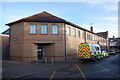
1
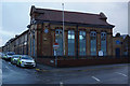
Bridlington Police Station
On Quay Road, Bridlington.
Image: © Ian S
Taken: 29 Nov 2017
0.01 miles
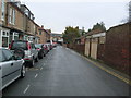
6
Havelock Street
Looking across Quay Road from the end of Havelock Street towards the police station.
Image: © DS Pugh
Taken: 16 Jul 2021
0.02 miles
7
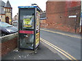
Telephone kiosk on Quay Road, Bridlington
On the junction with Portland Place.
Image: © Stefan De Wit
Taken: 4 Jul 2018
0.02 miles
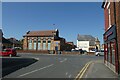
9
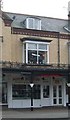
Charity shop on Quay Road, Bridlington
Image: © Stefan De Wit
Taken: 31 Oct 2010
0.02 miles