IMAGES TAKEN NEAR TO
Edwardian Drive, BRIDLINGTON, YO15 3TF
Introduction
This page details the photographs taken nearby to Edwardian Drive, YO15 3TF by members of the Geograph project.
The Geograph project started in 2005 with the aim of publishing, organising and preserving representative images for every square kilometre of Great Britain, Ireland and the Isle of Man.

There are currently over 7.5m images from over14,400 individuals and you can help contribute to the project by visiting https://www.geograph.org.uk
Image Map (Loading...)


Getting Data...Please wait
Leaflet Map data © OpenStreetMap
Images are licensed for reuse under creativecommons.org/licenses/by-sa/2.0
Notes
- Clicking on the map will re-center to the selected point.
- The higher the marker number, the further away the image location is from the centre of the postcode.
Image Listing (152 Images Found)
Images are licensed for reuse under creativecommons.org/licenses/by-sa/2.0
Image
Details
Distance


5
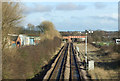
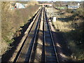
Railway towards Bridlington
The Yorkshire Coast Line runs between Seamer (near Scarborough) and Hull via Bridlington. The Bridlington to Hull section opened on 6 October 1846.
Image: © JThomas
Taken: 29 Nov 2012
0.05 miles
7
Railway towards Bridlington
The Yorkshire Coast Line runs between Seamer (near Scarborough) and Hull via Bridlington. The Bridlington to Hull section opened on 6 October 1846.
Image: © JThomas
Taken: 29 Nov 2012
0.05 miles


