IMAGES TAKEN NEAR TO
Cliff Lane, BRIDLINGTON, YO15 1JB
Introduction
This page details the photographs taken nearby to Cliff Lane, YO15 1JB by members of the Geograph project.
The Geograph project started in 2005 with the aim of publishing, organising and preserving representative images for every square kilometre of Great Britain, Ireland and the Isle of Man.

There are currently over 7.5m images from over14,400 individuals and you can help contribute to the project by visiting https://www.geograph.org.uk
Image Map
Images are licensed for reuse under creativecommons.org/licenses/by-sa/2.0
Notes
- Clicking on the map will re-center to the selected point.
- The higher the marker number, the further away the image location is from the centre of the postcode.
Image Listing (153 Images Found)
Images are licensed for reuse under creativecommons.org/licenses/by-sa/2.0
Image
Details
Distance
1

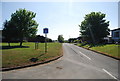
Down the hill into Bempton
Walking along Cliff Lane on the way from Bempton Cliffs to the railway station (which is just to the south of the village).
Image: © Barbara Carr
Taken: 21 Jun 2013
0.01 miles
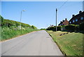
3

Footpath in Bempton
This short footpath (shown on the larger-scale map), over grassland in Bempton village, is a shortcut between Cliff Lane and School Lane.
Image: © Barbara Carr
Taken: 21 Jun 2013
0.02 miles
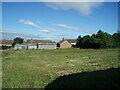


7
The Jawbones, Bempton
A strange name given to this road junction.
Image: © N Chadwick
Taken: 3 Jun 2010
0.05 miles
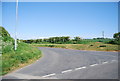
8
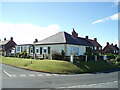
Bungalow on Cliff Lane
Junction with Green Lane.
Image: © JThomas
Taken: 5 Jul 2022
0.05 miles