IMAGES TAKEN NEAR TO
Filey Road, FILEY, YO14 9SS
Introduction
This page details the photographs taken nearby to Filey Road, YO14 9SS by members of the Geograph project.
The Geograph project started in 2005 with the aim of publishing, organising and preserving representative images for every square kilometre of Great Britain, Ireland and the Isle of Man.

There are currently over 7.5m images from over14,400 individuals and you can help contribute to the project by visiting https://www.geograph.org.uk
Image Map (Loading...)


Getting Data...Please wait
Leaflet Map data © OpenStreetMap
Images are licensed for reuse under creativecommons.org/licenses/by-sa/2.0
Notes
- Clicking on the map will re-center to the selected point.
- The higher the marker number, the further away the image location is from the centre of the postcode.
Image Listing (26 Images Found)
Images are licensed for reuse under creativecommons.org/licenses/by-sa/2.0
Image
Details
Distance
1
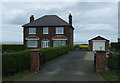
Greenacres
House on National Cycle Route 1.
Image: © JThomas
Taken: 25 May 2015
0.00 miles
2

Greenacres
North of Reighton, to the east of Moor Road.
Image: © Barbara Carr
Taken: 21 Jun 2013
0.02 miles
3
Butts Hill near Greenacres
National Cycle Route 1 heading south east towards Reighton.
Image: © JThomas
Taken: 25 May 2015
0.05 miles
4
Scarborough Road
Looking up the hill towards Reighton.
Image: © DS Pugh
Taken: 15 Jul 2021
0.05 miles
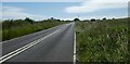
6

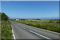
Coastal farmland
View from Hunmanby Road (A165).
Image: © JThomas
Taken: 25 May 2015
0.09 miles

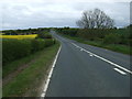
8
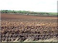
Ploughed field towards the A165
Looking towards the Reighton by-pass from the old A165 (National Cycle Route 1).
Image: © JThomas
Taken: 7 Feb 2016
0.11 miles
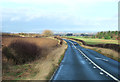
9
Looking down Butts Hill
The road is part of NCN route 1.
Image: © DS Pugh
Taken: 15 Jul 2021
0.11 miles
10

Oilseed rape crop near Greenacres
Off National Cycle Route 1.
Image: © JThomas
Taken: 25 May 2015
0.11 miles