IMAGES TAKEN NEAR TO
Ghyll Field, FILEY, YO14 9SL
Introduction
This page details the photographs taken nearby to Ghyll Field, YO14 9SL by members of the Geograph project.
The Geograph project started in 2005 with the aim of publishing, organising and preserving representative images for every square kilometre of Great Britain, Ireland and the Isle of Man.

There are currently over 7.5m images from over14,400 individuals and you can help contribute to the project by visiting https://www.geograph.org.uk
Image Map (Loading...)


Getting Data...Please wait
Leaflet Map data © OpenStreetMap
Images are licensed for reuse under creativecommons.org/licenses/by-sa/2.0
Notes
- Clicking on the map will re-center to the selected point.
- The higher the marker number, the further away the image location is from the centre of the postcode.
Image Listing (65 Images Found)
Images are licensed for reuse under creativecommons.org/licenses/by-sa/2.0
Image
Details
Distance
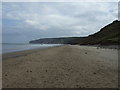
1
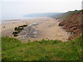
Reighton Sands
Looking SE along the beach from the west edge of the grid square.
Image: © Stephen Horncastle
Taken: 2 Jul 2006
0.06 miles
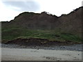
3
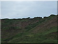
New Closes Cliff
Soft clay cliffs - wartime pillbox beginning to descend to the beach.
Image: © JThomas
Taken: 13 Jun 2014
0.08 miles
4
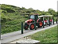
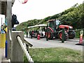
The tractor bus at Reighton Sands
A tractor and trailer is available to convey holiday-makers on the steep bank to the beach. It often travels down empty (as here), but does a lot of business on the way up!
Image: © Oliver Dixon
Taken: 19 May 2022
0.09 miles
5
The tractor bus at Reighton Sands
A tractor and trailer is available to convey holiday-makers on the steep bank to the beach. It often travels down empty, but (as here) does a lot of business on the way up!
Image: © Oliver Dixon
Taken: 19 May 2022
0.09 miles
6
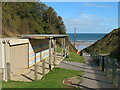
That end of season look
A sunny day in early October, but the holidaymakers have largely gone and the Beach Cafe is closed for the winter. This is the private road and path down The Gill from Reighton Sands Holiday Park to the beach and is a good deal less slippery than the right of way path to the shore a little further along.
Image: © Gordon Hatton
Taken: 7 Oct 2020
0.09 miles
7
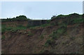
Pillbox, New Closes Cliff
Erosion causing to fall towards the beach.
Image: © JThomas
Taken: 13 Jun 2014
0.09 miles
8
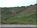
New Closes Cliff
Soft clay cliffs - wartime pillbox beginning to descend to the beach.
Image: © JThomas
Taken: 13 Jun 2014
0.09 miles
10
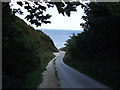
Track from Holiday Park down to Reighton Sands
Image: © JThomas
Taken: 23 Sep 2011
0.09 miles