IMAGES TAKEN NEAR TO
Lower Flat Cliffs, FILEY, YO14 9RE
Introduction
This page details the photographs taken nearby to Lower Flat Cliffs, YO14 9RE by members of the Geograph project.
The Geograph project started in 2005 with the aim of publishing, organising and preserving representative images for every square kilometre of Great Britain, Ireland and the Isle of Man.

There are currently over 7.5m images from over14,400 individuals and you can help contribute to the project by visiting https://www.geograph.org.uk
Image Map (Loading...)


Getting Data...Please wait
Leaflet Map data © OpenStreetMap
Images are licensed for reuse under creativecommons.org/licenses/by-sa/2.0
Notes
- Clicking on the map will re-center to the selected point.
- The higher the marker number, the further away the image location is from the centre of the postcode.
Image Listing (64 Images Found)
Images are licensed for reuse under creativecommons.org/licenses/by-sa/2.0
Image
Details
Distance
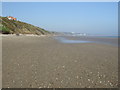
4
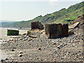
Concrete debris below Flat Cliffs
This appears to be a WWII installation that has been claimed by the seas. Flat Cliffs would be an obvious easy landing point.
Image: © Peter Church
Taken: 5 Jun 2008
0.05 miles
5

Houses on Lower Flat Cliff
On the left is the White House, previously owned by Billy Butlin - his Filey holiday camp was located nearby (now closed).
Image: © JThomas
Taken: 8 Oct 2013
0.05 miles
7

Beach Villa, Lower Flat Cliffs, Primrose Valley
Image: © PAUL FARMER
Taken: 17 Sep 2016
0.06 miles
9

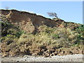
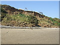
Flat Cliffs
The erosion on the southern reaches of Flat Cliffs is greater than a few hundred metres further north.
Image: © Peter Church
Taken: 5 Jun 2008
0.06 miles
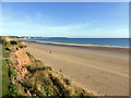
10
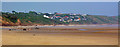
Flat Cliffs
This photograph was taken approximately 1 km south along the beach and gives a good view of how the houses follow the lie of the land.
Image: © Peter Church
Taken: 5 Jun 2008
0.07 miles