
IMAGES TAKEN NEAR TO
West Avenue, FILEY, YO14 9BQ
Introduction
This page details the photographs taken nearby to West Avenue, YO14 9BQ by members of the Geograph project.
The Geograph project started in 2005 with the aim of publishing, organising and preserving representative images for every square kilometre of Great Britain, Ireland and the Isle of Man.

There are currently over 7.5m images from over14,400 individuals and you can help contribute to the project by visiting https://www.geograph.org.uk
Image Map
Images are licensed for reuse under creativecommons.org/licenses/by-sa/2.0
Notes
- Clicking on the map will re-center to the selected point.
- The higher the marker number, the further away the image location is from the centre of the postcode.
Image Listing (46 Images Found)
Images are licensed for reuse under creativecommons.org/licenses/by-sa/2.0
Image
Details
Distance

2

View from field carpark towards Filey golf club entrance off West Av, Filey
Filey golf club on the right, on the left behind the trees is a council run 18 hole pitch and putt golf course.
Image: © Robert Christopher
Taken: 26 May 2017
0.05 miles
3

Pathway over railway line - Filey
Marked on the map you would be forgiven for thinking that this trackway would be vehicular, or at least metalled, but in fact this is what is actually here, a gravel trackway little more than a yard wide. Nevertheless it is a very popular trackway as it leads from Glen Park to two large caravan sites at its end. There are always people on it, night or day, even after the holiday season ends.
Image: © tracey Anne Taylor
Taken: 18 Aug 2012
0.08 miles
4
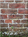
Bench mark on Occupation Bridge, Filey
This Ordnance Survey bench mark is on the north parapet of Occupation Bridge (HBS/41), which carries the Centenary Way over the East Coast railway line. See also Image
Image: © John S Turner
Taken: 16 Jun 2016
0.09 miles
5
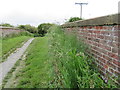
Occupation Bridge, Filey
Looking across Occupation Bridge (HBS/41), which carries the Centenary Way over the East Coast railway line. There is an Ordnance Survey bench mark on the parapet on the right - Image
Image: © John S Turner
Taken: 16 Jun 2016
0.09 miles
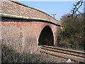
7
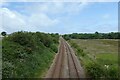
Railway line to Filey
Looking along the Yorkshire Coast Line. The section between Bridlington and Seamer is mostly single track, with the exception of the Hunmanby to Filey section to allow trains to pass.
Image: © DS Pugh
Taken: 15 Jul 2021
0.11 miles
8

Railway near Lowfield Farm caravan park
Looking down from a bridge onto the Yorkshire Coast Line. The section between Bridlington and Seamer is mostly single track, with the exception of the Hunmanby to Filey section to allow trains to pass each other.
Image: © DS Pugh
Taken: 15 Jul 2021
0.11 miles

10
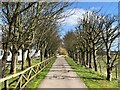
Centenary Way
Long distance footpath heading towards the coast.
Image: © Pauline E
Taken: 27 Mar 2021
0.14 miles