IMAGES TAKEN NEAR TO
Burton Fleming Road, FILEY, YO14 0JB
Introduction
This page details the photographs taken nearby to Burton Fleming Road, YO14 0JB by members of the Geograph project.
The Geograph project started in 2005 with the aim of publishing, organising and preserving representative images for every square kilometre of Great Britain, Ireland and the Isle of Man.

There are currently over 7.5m images from over14,400 individuals and you can help contribute to the project by visiting https://www.geograph.org.uk
Image Map
Images are licensed for reuse under creativecommons.org/licenses/by-sa/2.0
Notes
- Clicking on the map will re-center to the selected point.
- The higher the marker number, the further away the image location is from the centre of the postcode.
Image Listing (7 Images Found)
Images are licensed for reuse under creativecommons.org/licenses/by-sa/2.0
Image
Details
Distance
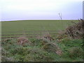
1
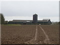
Farm buildings, Howe Farm
View from Hunmanby Road.
Image: © JThomas
Taken: 21 Feb 2020
0.11 miles
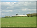
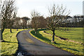
4
Howe Farm from the Edge of Field house Farm,Centenary Way.
Image: © tracey Anne Taylor
Taken: 11 Aug 2012
0.18 miles
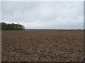
6
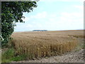
A Yorkshire Wolds Field
A typical view of the area.
Image: © Jason Exon
Taken: 30 Dec 2006
0.21 miles