IMAGES TAKEN NEAR TO
Bridlington Road, FILEY, YO14 0HJ
Introduction
This page details the photographs taken nearby to Bridlington Road, YO14 0HJ by members of the Geograph project.
The Geograph project started in 2005 with the aim of publishing, organising and preserving representative images for every square kilometre of Great Britain, Ireland and the Isle of Man.

There are currently over 7.5m images from over14,400 individuals and you can help contribute to the project by visiting https://www.geograph.org.uk
Image Map
Images are licensed for reuse under creativecommons.org/licenses/by-sa/2.0
Notes
- Clicking on the map will re-center to the selected point.
- The higher the marker number, the further away the image location is from the centre of the postcode.
Image Listing (22 Images Found)
Images are licensed for reuse under creativecommons.org/licenses/by-sa/2.0
Image
Details
Distance
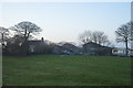
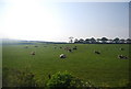
1
Lowfield Farm and Caravan Site
Still a working farm with a cash crop of caravans and holidaymakers.
Image: © Martin Dawes
Taken: 15 Dec 2009
0.02 miles
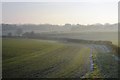
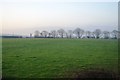
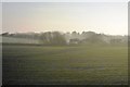
3
Pasture and hedge in blossom by the railway
Image: © N Chadwick
Taken: 3 Jun 2010
0.03 miles
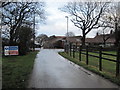
6
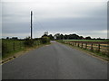
Wide track entrance to Lowfield Farm
Lowfield Farm is also a caravan site.
Image: © Phil Catterall
Taken: 16 Sep 2007
0.14 miles
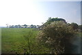
7
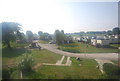
Muston Grange Farm Caravan Park south of Filey
Image: © N Chadwick
Taken: 3 Jun 2010
0.17 miles
9
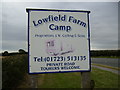
Sign at Lowfield Farm Camp - Royal Oak
Image: © Phil Catterall
Taken: 16 Sep 2007
0.18 miles