IMAGES TAKEN NEAR TO
Cooks Row, FILEY, YO14 0EP
Introduction
This page details the photographs taken nearby to Cooks Row, YO14 0EP by members of the Geograph project.
The Geograph project started in 2005 with the aim of publishing, organising and preserving representative images for every square kilometre of Great Britain, Ireland and the Isle of Man.

There are currently over 7.5m images from over14,400 individuals and you can help contribute to the project by visiting https://www.geograph.org.uk
Image Map
Images are licensed for reuse under creativecommons.org/licenses/by-sa/2.0
Notes
- Clicking on the map will re-center to the selected point.
- The higher the marker number, the further away the image location is from the centre of the postcode.
Image Listing (195 Images Found)
Images are licensed for reuse under creativecommons.org/licenses/by-sa/2.0
Image
Details
Distance
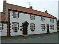
1
Hunmanby Street meets West Street
In the village of Muston.
Image: © Barbara Carr
Taken: 21 Jun 2013
0.00 miles

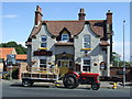
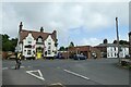
4

The Ship Inn, Muston
A freehouse selling some Sam Smith's products.
Image: © Ian S
Taken: 4 Jan 2014
0.02 miles
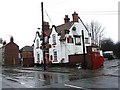
5
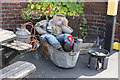
Drunken scarecrow, Muston
Appropriately outside the pub (Ship Inn).
Image: © JThomas
Taken: 30 Jul 2014
0.02 miles
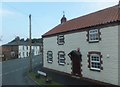
6
Hunmanby Street meets West Street
Looking across a road junction in Muston.
Image: © DS Pugh
Taken: 15 Jul 2021
0.02 miles
7

The Ship at Muston
Situated on the A1039 near the junction with Hunmanby Street.
Image: © Pauline E
Taken: 25 Nov 2011
0.02 miles