
IMAGES TAKEN NEAR TO
Undercliffe, SCARBOROUGH, YO13 9PX
Introduction
This page details the photographs taken nearby to Undercliffe, YO13 9PX by members of the Geograph project.
The Geograph project started in 2005 with the aim of publishing, organising and preserving representative images for every square kilometre of Great Britain, Ireland and the Isle of Man.

There are currently over 7.5m images from over14,400 individuals and you can help contribute to the project by visiting https://www.geograph.org.uk
Image Map
Images are licensed for reuse under creativecommons.org/licenses/by-sa/2.0
Notes
- Clicking on the map will re-center to the selected point.
- The higher the marker number, the further away the image location is from the centre of the postcode.
Image Listing (62 Images Found)
Images are licensed for reuse under creativecommons.org/licenses/by-sa/2.0
Image
Details
Distance
1
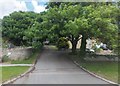
Cliff Lane, Snainton
Leading north from High Street (the A170). The residential road to the right is Undercliffe.
Image: © Barbara Carr
Taken: 16 Jun 2013
0.02 miles
2
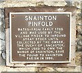
Details of plaque on pinfold, High Street, Snainton 1
This plaque details the history of the pinfold shown in Image
Image: © Christopher Hall
Taken: 11 Jan 2014
0.03 miles
3
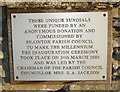
Details of plaque on pinfold, High Street, Snainton 2
This plaque gives details of the sundials mounted above the pinfold shown in Image
Image: © Christopher Hall
Taken: 11 Jan 2014
0.03 miles
4
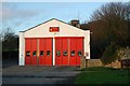
Snainton fire station
Snainton fire station, High Street, Snainton, North Yorkshire
Image: © Kevin Hale
Taken: 6 Dec 2009
0.03 miles
5
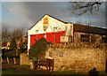
Pinfold and former fire station, High Street, Snainton
The stone structure is an 18th century pinfold and the brown plaque gives details of it. The other plaque details the sundials which are mounted above the pinfold wall. Behind is the former fire station which was operated by a retained crew. The fire station closed in 2013 and was for sale when photographed.
Image: © Christopher Hall
Taken: 11 Jan 2014
0.04 miles
6

Snainton, St Stephen's church
There is a bolt benchmark cut into the east facing wall of the church, and cut into a right cornerstone.
Image: © Mel Towler
Taken: 17 Mar 2023
0.04 miles
9

1 GL bench mark and bolt on Snainton church
This early bench mark and bolt is on the north east corner of St Stephen's church, Snainton. See also Image] For details of the mark see the Bench Mark Database http://www.bench-marks.org.uk/bm31345
Image: © John S Turner
Taken: 13 Jul 2010
0.06 miles
10
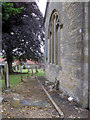
The east end of Snainton church, and a bench mark
Looking across the east end of St Stephen's church, Snainton. There is a bench mark and bolt on the nearest corner of the church on the second stone up - Image
Image: © John S Turner
Taken: 13 Jul 2010
0.06 miles