IMAGES TAKEN NEAR TO
Snainton, SCARBOROUGH, YO13 9PS
Introduction
This page details the photographs taken nearby to YO13 9PS by members of the Geograph project.
The Geograph project started in 2005 with the aim of publishing, organising and preserving representative images for every square kilometre of Great Britain, Ireland and the Isle of Man.

There are currently over 7.5m images from over14,400 individuals and you can help contribute to the project by visiting https://www.geograph.org.uk
Image Map
Images are licensed for reuse under creativecommons.org/licenses/by-sa/2.0
Notes
- Clicking on the map will re-center to the selected point.
- The higher the marker number, the further away the image location is from the centre of the postcode.
Image Listing (7 Images Found)
Images are licensed for reuse under creativecommons.org/licenses/by-sa/2.0
Image
Details
Distance
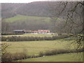
2
Near Cockmoor Hall Plantation
Looking down Troutsdale.
Image: © T Eyre
Taken: 15 Oct 2018
0.17 miles
4
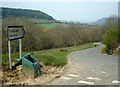
Looking down Troutsdale
The road from Snainton to Hackness on a hazy spring day.
Image: © David Pickersgill
Taken: 3 May 2008
0.20 miles
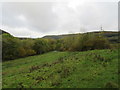
5
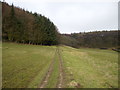
Public access route up into Broxa Forest
Image: © Phil Catterall
Taken: 13 Feb 2007
0.21 miles
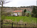
7
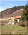
Keeper's Cottage, Troutsdale
Cottage in an idyllic spot in upper Troutsdale.
Image: © Gordon Hatton
Taken: 20 Apr 2013
0.23 miles