IMAGES TAKEN NEAR TO
Foulbridge Lane, SCARBOROUGH, YO13 9AZ
Introduction
This page details the photographs taken nearby to Foulbridge Lane, YO13 9AZ by members of the Geograph project.
The Geograph project started in 2005 with the aim of publishing, organising and preserving representative images for every square kilometre of Great Britain, Ireland and the Isle of Man.

There are currently over 7.5m images from over14,400 individuals and you can help contribute to the project by visiting https://www.geograph.org.uk
Image Map
Images are licensed for reuse under creativecommons.org/licenses/by-sa/2.0
Notes
- Clicking on the map will re-center to the selected point.
- The higher the marker number, the further away the image location is from the centre of the postcode.
Image Listing (10 Images Found)
Images are licensed for reuse under creativecommons.org/licenses/by-sa/2.0
Image
Details
Distance
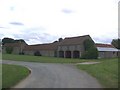
2

Foulbridge Farm
Attached to this farm house is a Knights Templar hall, which cannot be seen from the road,for more details see:
http://www.yorkshirehistory.com/templars/temp.htm
Image: © Michael Jagger
Taken: 31 Jan 2010
0.04 miles
3
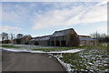
Foulbridge Farm
Attached to this farm house is a Knights Templar hall, which cannot be seen from the road,for more details see:
http://www.yorkshirehistory.com/templars/temp.htm
Image: © Michael Jagger
Taken: 31 Jan 2010
0.06 miles
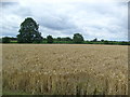
5
Track and Bridleway to Middle Lane
From Foulbridge Farm east to Snainton Ings House
Image: © Martin Dawes
Taken: 8 May 2013
0.12 miles
6

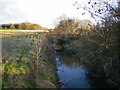
River Derwent at Foulbridge
Looking east upstream, the river has been straightened here, and you can see the old course on the OS map as the Ryedale/Scarborough district boundary.
Image: © T Eyre
Taken: 3 May 2016
0.16 miles
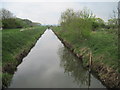
7
Bridge over the River Derwent at Foulbridge
The river here is in two channels, presumably one is the original line and the other wider channel is man made. See other photo.
Image: © Phil Catterall
Taken: 22 Jan 2007
0.20 miles
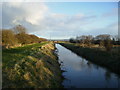
8
The River Derwent at Foul Bridge
Looking upstream.
Image: © Jonathan Thacker
Taken: 22 Sep 2018
0.20 miles
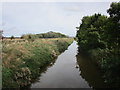
9
River Derwent east from Foul Bridge
The drainage of the Vale of Pickering is done mainly through this river, many sections have been straightened to increase the flow. it was not navigable to here only to Yedingham the next village and bridge west of this point.
Image: © Martin Dawes
Taken: 8 May 2013
0.21 miles
10
The wider section of the River Derwent at Foulbridge
See other photo for comment.
Image: © Phil Catterall
Taken: 22 Jan 2007
0.22 miles