IMAGES TAKEN NEAR TO
Lairs Lane, SCARBOROUGH, YO13 9AH
Introduction
This page details the photographs taken nearby to Lairs Lane, YO13 9AH by members of the Geograph project.
The Geograph project started in 2005 with the aim of publishing, organising and preserving representative images for every square kilometre of Great Britain, Ireland and the Isle of Man.

There are currently over 7.5m images from over14,400 individuals and you can help contribute to the project by visiting https://www.geograph.org.uk
Image Map
Images are licensed for reuse under creativecommons.org/licenses/by-sa/2.0
Notes
- Clicking on the map will re-center to the selected point.
- The higher the marker number, the further away the image location is from the centre of the postcode.
Image Listing (28 Images Found)
Images are licensed for reuse under creativecommons.org/licenses/by-sa/2.0
Image
Details
Distance
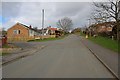
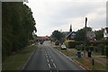
2

Lair's Lane, Snainton
A minor road leading north past the school from Snainton High Street (the A170).
Image: © Barbara Carr
Taken: 16 Jun 2013
0.03 miles

4

Snainton War Memorial
At the junction of Lairs Lane and the A170 seen to the left
Image: © Martin Dawes
Taken: 25 Oct 2017
0.07 miles
5
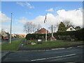
Snainton War Memorial
At the junction of Lairs Lane and the A170 High Street
Image: © Martin Dawes
Taken: 29 Apr 2021
0.07 miles
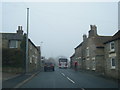
6

High Street, Snainton
Snainton Primary School on the right.
Image: © J.Hannan-Briggs
Taken: 15 Mar 2017
0.08 miles