IMAGES TAKEN NEAR TO
High Street, SCARBOROUGH, YO13 0PS
Introduction
This page details the photographs taken nearby to High Street, YO13 0PS by members of the Geograph project.
The Geograph project started in 2005 with the aim of publishing, organising and preserving representative images for every square kilometre of Great Britain, Ireland and the Isle of Man.

There are currently over 7.5m images from over14,400 individuals and you can help contribute to the project by visiting https://www.geograph.org.uk
Image Map
Images are licensed for reuse under creativecommons.org/licenses/by-sa/2.0
Notes
- Clicking on the map will re-center to the selected point.
- The higher the marker number, the further away the image location is from the centre of the postcode.
Image Listing (145 Images Found)
Images are licensed for reuse under creativecommons.org/licenses/by-sa/2.0
Image
Details
Distance


4

Commemorative Fountain
Built to commemorate the Diamond Jubilee of Queen Victoria in 1897.
Image: © N Chadwick
Taken: 1 Jun 2010
0.04 miles
6
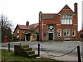
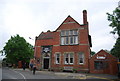
Scalby Methodist Hall
The shelter to the left of the Hall bears a plaque in memory of those men and women of the Scalby urban district who served in the 1939 - 1945 war.
Image: © David Rogers
Taken: 17 Feb 2009
0.05 miles
9
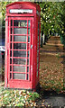
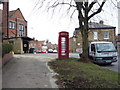
Scalby phone box
K6 phone box in the centre of the village.
Image: © Robert Walton
Taken: 17 Oct 2016
0.05 miles
10

Scalby phone box
Close up of K6 phone box in the centre of the village.
Image: © Robert Walton
Taken: 21 Oct 2016
0.05 miles