IMAGES TAKEN NEAR TO
Lindhead Road, SCARBOROUGH, YO13 0DL
Introduction
This page details the photographs taken nearby to Lindhead Road, YO13 0DL by members of the Geograph project.
The Geograph project started in 2005 with the aim of publishing, organising and preserving representative images for every square kilometre of Great Britain, Ireland and the Isle of Man.

There are currently over 7.5m images from over14,400 individuals and you can help contribute to the project by visiting https://www.geograph.org.uk
Image Map
Images are licensed for reuse under creativecommons.org/licenses/by-sa/2.0
Notes
- Clicking on the map will re-center to the selected point.
- The higher the marker number, the further away the image location is from the centre of the postcode.
Image Listing (5 Images Found)
Images are licensed for reuse under creativecommons.org/licenses/by-sa/2.0
Image
Details
Distance
2
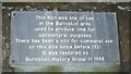
Plaque on lime kiln, Stone Quarry Road
Details of a plaque on the lime kiln shown in Image
Image: © Christopher Hall
Taken: 16 Feb 2014
0.13 miles
3
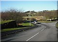
Lime kiln, Stone Quarry Road, Burniston
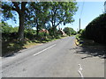
Stone Quarry Road approaches from behind the camera. Its continuation around the bend is Lindhead Road. On the left is a lime kiln said to be one of ten in Burniston Parish. This kiln was restored in 1988 and further restoration was done about three years ago.
The road going off to the right goes to Cloughton Quarries, however these produced good quality sandstone for building purposes, not limestone.
Image: © Christopher Hall
Taken: 16 Feb 2014
0.14 miles
5
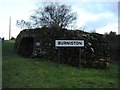
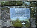
Lime Kiln Burniston
This old Lime Kiln at the side of the Lindhead Road as it enters the village
Image: © Martin Dawes
Taken: 11 Feb 2009
0.15 miles