IMAGES TAKEN NEAR TO
Hackness, SCARBOROUGH, YO13 0BS
Introduction
This page details the photographs taken nearby to YO13 0BS by members of the Geograph project.
The Geograph project started in 2005 with the aim of publishing, organising and preserving representative images for every square kilometre of Great Britain, Ireland and the Isle of Man.

There are currently over 7.5m images from over14,400 individuals and you can help contribute to the project by visiting https://www.geograph.org.uk
Image Map
Images are licensed for reuse under creativecommons.org/licenses/by-sa/2.0
Notes
- Clicking on the map will re-center to the selected point.
- The higher the marker number, the further away the image location is from the centre of the postcode.
Image Listing (7 Images Found)
Images are licensed for reuse under creativecommons.org/licenses/by-sa/2.0
Image
Details
Distance
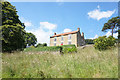
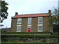
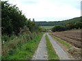
3
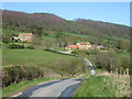
Troutsdale Low Hall
View northeast from approx. SE929896.
Image: © Dave Dunford
Taken: 28 Jan 2006
0.06 miles
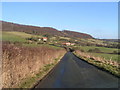
4
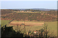
View from the Raptor Viewing Point
Troutsdale. Magnificent view across the valley today in winter sun but with a biting wind. Goshawk present, but alas, not photographed.
Image: © Pauline E
Taken: 24 Jan 2015
0.07 miles
6
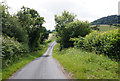
Troutsdale Lane
Troutsdale Lane near Troutsdale Low Hall.
Image: © T Eyre
Taken: 30 Apr 2012
0.12 miles