IMAGES TAKEN NEAR TO
Melrose Street, SCARBOROUGH, YO12 7SH
Introduction
This page details the photographs taken nearby to Melrose Street, YO12 7SH by members of the Geograph project.
The Geograph project started in 2005 with the aim of publishing, organising and preserving representative images for every square kilometre of Great Britain, Ireland and the Isle of Man.

There are currently over 7.5m images from over14,400 individuals and you can help contribute to the project by visiting https://www.geograph.org.uk
Image Map
Images are licensed for reuse under creativecommons.org/licenses/by-sa/2.0
Notes
- Clicking on the map will re-center to the selected point.
- The higher the marker number, the further away the image location is from the centre of the postcode.
Image Listing (251 Images Found)
Images are licensed for reuse under creativecommons.org/licenses/by-sa/2.0
Image
Details
Distance
1

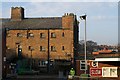
Social Housing Trafalgar Street West/Melrose Street junction
At the junction of Trafalgar Street West and Melrose Street this social housing was built by the Scarborough Municipal Charity in 1982. The site was previously occupied by the Central Schools.
Image: © Christopher Hall
Taken: 10 Dec 2013
0.04 miles
2
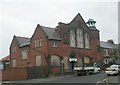
Former gaol cell block in Dean Road Depot
Looking across the yard of Dean Road Depot to the former gaol cell block within the depot. The prison was designed in 1866 by the local architect William Baldwin Stewart and the Borough Engineer Alexander Taylor to replace the Borough Gaol on Castle Road; it cost £8,755. It was designed to be a model prison with advanced facilities. Stewart designed it to look like a castle; and here the cell blocks are designed to emulate a castle 'keep'.
Image: © Christopher Hall
Taken: 10 Dec 2013
0.04 miles
3

Plaque on Genevieve Court, Trafalgar Street West
Details of a plaque marking the building of the social housing at the junction of Trafalgar Street West and Melrose Street. The 'Genevieve' referred to is Genevieve Lord M.B.E. a Fremman of the Borough of Scarborough and Trustee of the Scarborough Municipal Charity amongst other things.
Image: © Christopher Hall
Taken: 10 Dec 2013
0.04 miles
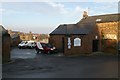
4

Former Dean Road Prison
This is now a local authority depot.
Image: © Betty Longbottom
Taken: 7 Sep 2010
0.05 miles
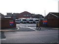
5
Dean Road Depot from Trafalgar Street West
This view of the Council Depot shows the Trafalgar Street West entrance and the 'upper yard'. Above the white vans can be seen the entrance to the former gaol off Dean Road shown in Image
Image: © Christopher Hall
Taken: 10 Dec 2013
0.05 miles
7
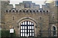
Dean Road Depot, former prison
Details of the entrance 'gatehouse' to the former prison now Dean Road Depot. There are mock machicolations, a slot for a portcullis, chains for a drawbridge and 'arrow slot' windows. The roundel at the top contains a reproduction of the towns medieval seal and there is a Heritage trail plaque to the right of the door.
Image: © Christopher Hall
Taken: 10 Dec 2013
0.06 miles
8
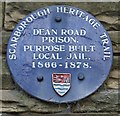
Heritage Trail plaque on former prison, Dean Road
Details on the blue heritage trail plaque on the entrance to the former prison
Image: © Christopher Hall
Taken: 10 Dec 2013
0.06 miles
9
Wesley Methodist Church - Hoxton Road
Image: © Betty Longbottom
Taken: 7 Sep 2010
0.06 miles
10
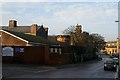
Council Depot, Dean Road
View down Dean road showing the main vehicle entrance to the Council Depot. Parts of this depot were the 19th century prison and in this view the mock gatehouse and perimeter walls can be seen with the cell block behind emulating a castle keep. St Columba's Church in the right background.
Image: © Christopher Hall
Taken: 10 Dec 2013
0.06 miles